Vlieland

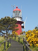
Vlieland (Dutch pronunciation: [ˈvlilɑnt] ; West Frisian: Flylân [ˈflilɔ̃ːn]) is a municipality and island in the northern Netherlands. The municipality of Vlieland is the second most sparsely populated municipality in the Netherlands, after Schiermonnikoog. Vlieland is one of the West Frisian Islands, lying in the Wadden Sea. It is the second island from the west in the chain, lying between Texel and Terschelling. The island was permanently separated from the mainland in St. Lucia's flood in 1287. Vlieland was named after the Vlie, the seaway between it and Terschelling that was the estuary of the river IJssel in medieval times. Richel is a permanently dry sandbank, located about 1 kilometer east of the northernmost point of Vlieland and is administered by the municipality of Vlieland.
Excerpt from the Wikipedia article Vlieland (License: CC BY-SA 3.0, Authors, Images).Vlieland
Lange Baan, Vlieland
Geographical coordinates (GPS) Address Nearby Places Show on map
Geographical coordinates (GPS)
| Latitude | Longitude |
|---|---|
| N 53.3 ° | E 5.0666666666667 ° |
Address
Lange Baan
8899 BA Vlieland
Frisia, Netherlands
Open on Google Maps


