place

Shutesbury, Massachusetts

Shutesbury, MassachusettsSpringfield metropolitan area, MassachusettsTowns in Franklin County, MassachusettsTowns in MassachusettsUse mdy dates from July 2023
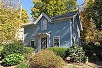
Community Church, Shutesbury MA

Shutesbury is a town in Franklin County, Massachusetts, United States. The population was 1,717 at the 2020 census. It is part of the Springfield, Massachusetts Metropolitan Statistical Area.

Excerpt from the Wikipedia article Shutesbury, Massachusetts (License: CC BY-SA 3.0, Authors, Images).

Shutesbury, Massachusetts
Wendell Road,

Geographical coordinates (GPS) Address Nearby Places
placeShow on map

Wikipedia: Shutesbury, MassachusettsContinue reading on Wikipedia

Geographical coordinates (GPS)

Latitude Longitude
N 42.456388888889 ° E -72.410277777778 °
placeShow on map

Address

Wendell Road 72
01072
Massachusetts, United States
mapOpen on Google Maps

Community Church, Shutesbury MA
Share experience

Nearby Places

South School (Shutesbury, Massachusetts)

The South School is a historic one-room schoolhouse at 6 Schoolhouse Rd. in Shutesbury, Massachusetts. It is one of two such schoolhouses remaining in Shutesbury, and is a rare example of a side-gable construction. Its date of construction is uncertain, but is estimated to be about 1830. Because of the simplicity of the building, the presence of both Federal and Greek Revival elements in its design, and the comparatively late adoption of Greek Revival styles in the rural community, the school may have been built at a later date.The schoolhouse sits about 15 feet off Schoolhouse Road and 50 feet from Baker Road, with its gable end facing the street. The 1+1⁄2-story building sits on a granite slab foundation, and has a chimney on its western wall. It measures about 25.5 feet by 18 feet, and there is a shed structure attached to the east wall. The main entrance is set in the right side of the south wall. The entry leads into a vestibule area, from which there is then entry into the schoolroom. There is a closet in the northeast corner, from which a hatch provides access to the attic area. The walls of the interior have a bead-board wainscoting, with horizontal tongue-and-groove boards rising to the ceiling. The classroom floor is wide pine, while that of the entry is narrow fir strips.From its construction until 1928 the building served as a school, and was known as the District 8 School or the Moses S. Bartlett School, after a nearby resident. Its use declined after 1881, when the town abolished its districts, but was occasionally used due to fluctuating enrollments. The district schools were permanently closed in 1928, and elementary classes were centralized. The town sold the school for $200 in 1939, and it was converted to residential use. In 1993 the property was given to the Sirius Community, a nearby spiritual and educational organization, which has since undertaken the building's rehabilitation. The property was listed on the National Register of Historic Places in 2007.

Pelham Town Hall Historic District

The Pelham Town Hall Historic District encompasses the remaining municipal portion of the center of Pelham, Massachusetts as laid out between 1738 and 1743. It includes the Old Town Hall, built in 1743, which is claimed by the town to be the oldest continuously used town hall in the United States. It also includes the 1843 Greek Revival Congregational church, and the town's first cemetery, founded in 1739. The district was listed on the National Register of Historic Places in 1971.The land which became Pelham was acquired by the Lisburn Proprietors, Scotch-Irish emigrants, in 1738. The next year, a lot of 10 acres (4.0 ha) was laid out for a meeting house, town pound, training field, and cemetery. The meeting house (now the town hall) was built on this parcel in 1743. Initially used for both religious and civic purposes, its religious function ended after the state mandated the separation of church and state in 1833. The Greek Revival church was built next door in 1839; it now houses the local historical society. The town center is historically significant as the last organized encampment site of rebel forces led by Daniel Shays during the Shays' Rebellion.The town hall is a two-story wood-frame structure, with a gabled roof and clapboarded exterior. Its main facade is five bays wide, with a projecting central square vestibule. The church is a single-story frame structure, with its gabled roof oriented perpendicular to that of the town hall. It has corner pilasters, which rise to an entablature, and it is topped by a single-stage square belfry with octagonal spire.