place

Robinson's Warehouse, Bristol

1874 establishments in EnglandBrick buildings and structuresBristol HarboursideBristol building and structure stubsByzantine Revival architecture in the United Kingdom
Grade II listed buildings in BristolGrade II listed industrial buildingsIndustrial buildings completed in 1874Use British English from August 2017Warehouses in England
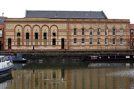
Robinsons Warehouse Bristol

Robinson's Warehouse (grid reference ST585725) is a warehouse on Bathurst Parade, on the Floating Harbour in Bristol, England. It was built in 1874 by William Bruce Gingell, and is an example of the Bristol Byzantine style with yellow and red brick and Moorish arches.It was formerly the warehouse of Robinson's Oil Seed Manufactory, and has also been known as Warriner's Warehouse. It has been designated by English Heritage as a grade II listed building.

Excerpt from the Wikipedia article Robinson's Warehouse, Bristol (License: CC BY-SA 3.0, Authors, Images).

Robinson's Warehouse, Bristol
Bathurst Parade, Bristol Southville

Geographical coordinates (GPS) Address Nearby Places
placeShow on map

Wikipedia: Robinson's Warehouse, BristolContinue reading on Wikipedia

Geographical coordinates (GPS)

Latitude Longitude
N 51.4475 ° E -2.5951 °
placeShow on map

Address

Bathurst Parade
BS1 6UA Bristol, Southville
England, United Kingdom
mapOpen on Google Maps

Robinsons Warehouse Bristol
Share experience

Nearby Places

Bathurst Basin
Bathurst Basin

Bathurst Basin is a small triangular basin adjoining the main harbour of the city of Bristol, England. The basin takes its name from Charles Bathurst, who was a Bristol MP in the early 19th century.The basin was built on an area of an old mill pond, Trin Mills. The pond was supplied by the River Malago, from Bedminster to the South. It lost its water supply as the New Cut was created in 1809, running to the South of the enlarged Floating Harbour and catching the flow of the Malago. After this it formed a connecting basin, through two sets of locks, between the Floating Harbour and the tidal River Avon in the New Cut. The connection enabled smaller vessels to bypass the main entrance locks in Cumberland Basin. From 1865 a deep water dock with a stone quay front was built. The area used to be an industrial dock with warehouses and numerous shipyards at the adjoining Wapping Shipyard and Docks, including Hilhouse, William Scott & Sons and William Patterson. Now there is a small marina, with residential quayside properties. The Bristol Harbour Railway connected to the main line system at Temple Meads, via a lifting bascule bridge over the northern entrance dock to the basin and a tunnel beneath St Mary Redcliffe. The tunnel still exists, but is now blocked, and the original railway bridge has been replaced with a swing footbridge. This bridge is manually swung by a hydraulic pump action.Bristol General Hospital is located on the Eastern quay of the basin. When constructed in 1859, the hospital was built with basement warehouse space to defray its operating costs. The Southern quay has never had any substantial buildings on it and for many years was used by Holms Sand & Gravel Co. as a depot for building materials, brought in by boat and offloaded into road vehicles. A travelling crane on an overhead gantry was used to handle these.