place

Perkins Homes, Baltimore

Baltimore geography stubsPublic housing in Baltimore
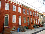
Perkins Homes (1942), Bank Street and S. Caroline Street (northeast corner), Baltimore, MD 21231 (34997139456)

Perkins Homes was a former public housing development in Southeast Baltimore, located between Fells Point and Little Italy and bounded by Pratt Street to the north, Eden Street on the west, Dallas Street on the east, and Bank Street to the south. The community was located within the East Harbor Empowerment Zone of the Fells Point area, and was one of the oldest housing projects in southeast Baltimore. The housing project tenants were about 91% African-American, 7% Puerto Rican, and 2% white prior to relocation and demoliton.City Springs Elementary School is located at South Caroline and East Pratt Streets. Lombard Junior High School and First Apostolic Institution Church are nearby. In 2019, the Housing Authority of Baltimore City received $30 million in federal funding to demolish Perkins Homes. Current plans are for a new mixed-use community of replacement public housing and market rate apartments.

Excerpt from the Wikipedia article Perkins Homes, Baltimore (License: CC BY-SA 3.0, Authors, Images).

Perkins Homes, Baltimore
South Dallas Court, Baltimore

Geographical coordinates (GPS) Address Nearby Places
placeShow on map

Wikipedia: Perkins Homes, BaltimoreContinue reading on Wikipedia

Geographical coordinates (GPS)

Latitude Longitude
N 39.287777777778 ° E -76.596305555556 °
placeShow on map

Address

South Dallas Court 299
21223 Baltimore
Maryland, United States
mapOpen on Google Maps

Perkins Homes (1942), Bank Street and S. Caroline Street (northeast corner), Baltimore, MD 21231 (34997139456)
Share experience

Nearby Places

Jonestown, Baltimore

Jonestown is a neighborhood in the southeastern district of Baltimore. Its boundaries are the north side of Pratt Street, the west side of Central Avenue, the east side of Fallsway, and the south side of Orleans Street. The neighborhood lies north of the Little Italy, south of the Old Town, west of the Washington Hill, and east of the Downtown Baltimore neighborhoods. The southern terminus of the Jones Falls Expressway is located here. Jonestown is a historical section of southeast Baltimore established in 1732 that was laid out on 10 acres (40,000 m2) divided into twenty lots on the east side of the Jones Falls. The district is a mix of industrial, commercial and residential buildings. In the last half of the 20th century, Jonestown has shifted from a predominantly Eastern European and Jewish neighborhood into a predominantly African-American neighborhood. Public housing replaced many of the former rowhouses and townhouses throughout the area, though a historical presence is still felt. In the early 2000s, though, modern row housing replaced the public housing. Jonestown is home to Baltimore's central post office in addition to 8 Baltimore City Landmarks including the Flag House; the Jewish Museum of Maryland, home of the Lloyd Street Synagogue; the Reginald F. Lewis Museum of Maryland African American History and Culture; the Carroll Mansion; the Phoenix Shot Tower; the Old Town Friends' Meeting House; The House at 9 North Front Street; and the McKim's School.