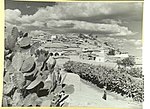
Qatra
Arab villages depopulated prior to the 1948 Arab–Israeli WarDistrict of Ramla

Qatra (Arabic: قطرة) was a Palestinian Arab village in the Ramle Subdistrict, located 15 kilometers (9.3 mi) southwest of the city of Ramla and 40 kilometers (25 mi) west of Jerusalem, some 50 meters (160 ft) above sea level. It was depopulated in May 1948.
Excerpt from the Wikipedia article Qatra (License: CC BY-SA 3.0, Authors, Images).Qatra
Sprinzak,
Geographical coordinates (GPS) Address Nearby Places Show on map
Geographical coordinates (GPS)
| Latitude | Longitude |
|---|---|
| N 31.821916666667 ° | E 34.777527777778 ° |
Address
שפרינצק
Sprinzak
6094600
Center District, Israel
Open on Google Maps


