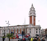
Coldharbour Lane

Coldharbour Lane is a road in south London, England, that leads south-westwards from Camberwell to Brixton. The road is over 1 mile (1.6 km) long with a mixture of residential, business and retail buildings - the stretch of Coldharbour Lane near Brixton Market contains shops, bars and restaurants. Between the junctions of Coldharbour Lane and Denmark Hill in Camberwell SE5 and Coldharbour Lane and Denmark Road lies part of the boundary between Lambeth and Southwark boroughs. The other end of Coldharbour Lane meets Acre Lane in central Brixton to form the A2217. The Loughborough Junction area, surrounding the railway station, marks the approximate centre point of Coldharbour Lane and the change in postcode from SE5 to SW9.
Excerpt from the Wikipedia article Coldharbour Lane (License: CC BY-SA 3.0, Authors, Images).Coldharbour Lane
Coldharbour Lane, London Loughborough Junction (London Borough of Lambeth)
Geographical coordinates (GPS) Address Nearby Places Show on map
Geographical coordinates (GPS)
| Latitude | Longitude |
|---|---|
| N 51.4659 ° | E -0.1024 ° |
Address
Cheap Chinese and Caribbean food
Coldharbour Lane
SW9 8SA London, Loughborough Junction (London Borough of Lambeth)
England, United Kingdom
Open on Google Maps


