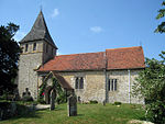
Boxley

Boxley is a village and civil parish in the Maidstone District of Kent, England. It lies below the slope of the North Downs approximately 2 miles (3.2 km) northeast of the centre of Maidstone town. The civil parish has a population of 7,144 (2001 census), increasing to 9,554 at the 2011 Census, and extends to the north and east of the town including the settlements of Boxley itself, Grove Green, most of Weavering Street, Sandling and the southern extremities of Walderslade and Lordswood at the top of Blue Bell Hill. The M2 and M20 motorways cross the parish to the north and south of Boxley village and the High Speed 1 railway line passes to the south in cuttings and tunnel. Despite being so close to Maidstone and two motorways, the village is surrounded by woodland, and still retains a village feel. The ruins of Boxley Abbey, in neighbouring Sandling, fall within the parish.
Excerpt from the Wikipedia article Boxley (License: CC BY-SA 3.0, Authors, Images).Boxley
The Street,
Geographical coordinates (GPS) Address Website Nearby Places Show on map
Geographical coordinates (GPS)
| Latitude | Longitude |
|---|---|
| N 51.302424 ° | E 0.542887 ° |
Address
Kings Arms
The Street
ME14 3DR , Boxley
England, United Kingdom
Open on Google Maps


