RAF Chilbolton

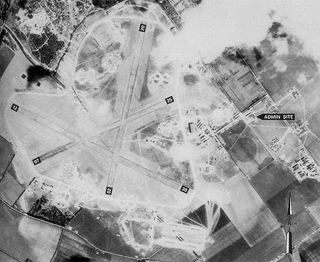
Royal Air Force Chilbolton or RAF Chilbolton was a Royal Air Force station in Hampshire, England. The airfield was located in Chilbolton approximately 4 miles (6.4 km) south-southeast of Andover, about 62 miles (100 km) southwest of London Opened in 1940, it was used by the Royal Air Force and later by the United States Army Air Forces. During the war it was used primarily as a troop carrier airfield for parachutists. After the war it was used for military jet aircraft training before closing as an RAF station in 1946, although it was then used until the early 1960s by the Vickers-Supermarine and Folland aircraft companies for flight testing and development flying. Today the remains of the airfield are located on private property, being used as agricultural fields.
Excerpt from the Wikipedia article RAF Chilbolton (License: CC BY-SA 3.0, Authors, Images).RAF Chilbolton
Mark Way, Test Valley Chilbolton
Geographical coordinates (GPS) Address Nearby Places Show on map
Geographical coordinates (GPS)
| Latitude | Longitude |
|---|---|
| N 51.143333333333 ° | E -1.4397222222222 ° |
Address
Mark Way
Mark Way
SO20 6AN Test Valley, Chilbolton
England, United Kingdom
Open on Google Maps


