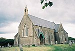
Symondsbury
EngvarB from June 2016Villages in Dorset

Symondsbury () is a village and civil parish in southwest Dorset, England, 1.5 miles (2.4 km) west of Bridport and 16 miles (26 km) west of Dorchester. The village is located just to the north of the A35 trunk road, which runs between Southampton and Honiton. The village has a pub (the Ilchester Arms), a pottery and a primary school. The village is the head of Symondsbury Parish which extends from Eype and West Cliff (West Bay) in the south, to the Marshwood Vale in the north. The village is set in the Dorset Area of Outstanding Natural Beauty (AONB). In the 2011 census the parish had a population of 1,059.
Excerpt from the Wikipedia article Symondsbury (License: CC BY-SA 3.0, Authors, Images).Symondsbury
Mill Lane,
Geographical coordinates (GPS) Address Nearby Places Show on map
Geographical coordinates (GPS)
| Latitude | Longitude |
|---|---|
| N 50.7395 ° | E -2.7875 ° |
Address
Mill Lane
Mill Lane
DT6 6HQ , Symondsbury
England, United Kingdom
Open on Google Maps


