place

Hoo Fort

Forts in MedwayPalmerston FortsUse British English from April 2018
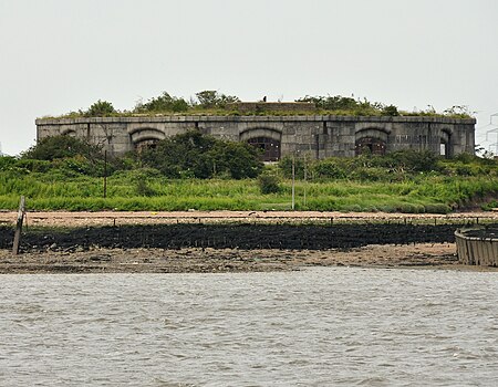
Hoo Fort
Hoo Fort

Hoo Fort is a nineteenth-century military installation on the River Medway in Kent, England, that formed part of the defences of Chatham Naval Dockyard. Hoo Fort, like Fort Darnet 1 km (0.6 mi) downstream, was built on the recommendations of the 1859 Royal Commission. It is located on Hoo Island covering Pinup Reach, the inner navigable channel of the River Medway. Hoo Island sits to the south of the Hoo Peninsula and is within the parish of Hoo, Kent. The fort can be viewed from along the Saxon Shore Way, accessible from Vicarage Lane in Hoo.

Excerpt from the Wikipedia article Hoo Fort (License: CC BY-SA 3.0, Authors, Images).

Geographical coordinates (GPS)

Latitude Longitude
N 51.403333333333 ° E 0.58138888888889 °
placeShow on map

Address

Hoo Fort

Copperhouse Lane
ME7 2XS
England, United Kingdom
mapOpen on Google Maps

linkWikiData (Q5471349)
linkOpenStreetMap (122052898)

Hoo Fort
Hoo Fort
Share experience

Nearby Places

Fort Darnet
Fort Darnet

Fort Darnet, is a nineteenth-century military installation on the River Medway in Kent, England, that formed part of the defences of Chatham Naval Dockyard. Fort Darnet, like its twin Hoo Fort 1 km (0.6 mi) upstream, was built on the recommendations of the 1859 Royal Commission on an island covering Pinup Reach, the inner navigable channel of the River Medway. Building started on the island in 1870 and then finished in 1872. Originally designed for two tiers of guns mounted in a circle, with a boom strung between them, there were many problems with subsidence, and after extensive cost overruns the forts were completed in 1872 with one tier, and 11 guns : a mixture of 8 9-inch and 3 7-inch rifled muzzle-loaders. The boom was not implemented though there were plans to mine the channel if thought needed. It was originally designed for a garrison of up to 100 men.The fort was used for gunnery practice until one of the guns cracked in its casemate, as reported in ‘The Chatham Observer’ on 25 January 1879.The forts were never used in anger, and were decommissioned before the First World War. In the Second World War the fort was used as an observation post, with platforms and pillboxes built on top. The fort is still in fair condition, however the magazine level is flooded. The island can be freely visited by boat, though the landing is muddy. Up to the 1980s, the island was used for picnicking and other leisure pursuits.It is scheduled under the Ancient Monuments and Archaeological Areas Act 1979.