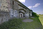
Coalhouse Fort

Coalhouse Fort is an artillery fort in the eastern English county of Essex. It was built in the 1860s to guard the lower Thames from seaborne attack. It stands at Coalhouse Point on the north bank of the river, at a location near East Tilbury which was vulnerable to raiders and invaders. It was the last in a series of fortifications dating back to the 15th century and was the direct successor to a smaller mid-19th century fort built on the same site. Constructed during a period of tension with France, its location on marshy ground caused problems from the start and led to a lengthy construction process. The fort was equipped with a variety of large-calibre artillery guns and the most modern defensive facilities of the time, including shell-proof casemates protected by granite facing and cast-iron shields. Its lengthy construction and the rapid pace of artillery development at the time meant that it was practically obsolete for its original purpose within a few years of its completion. The fort's armament was revised several times during its 70 years of military use, as its role evolved in the river's defensive system. It was initially a front-line fortification, supported by Shornemead Fort and Cliffe Fort located to the south and east respectively on the Kent shore. Over time, as batteries and forts further downriver became the front line of the Thames defences, Coalhouse Fort was stripped of its main weapons and it was altered to support smaller quick-firing guns intended to be used against fast-moving surface and aerial targets. Its last military use was as a training facility for a few years after the Second World War. Decommissioned in 1949, the fort was used as a storehouse for a shoe factory before it was purchased by the local council. The surrounding land was developed into a public park, but the fort itself fell into dereliction despite its historical and architectural significance. From 1985 it was leased to a voluntary preservation group, the Coalhouse Fort Project, which had been working to restore the fort and use it for heritage and educational purposes. Funding for its restoration was provided in part by the Heritage Lottery Fund and the Warner Bros. film studio, which used the fort as a location for the opening scenes of the 2005 film Batman Begins. The group closed in 2020.
Excerpt from the Wikipedia article Coalhouse Fort (License: CC BY-SA 3.0, Authors, Images).Coalhouse Fort
Princess Margaret Road, Thurrock
Geographical coordinates (GPS) Address External links Nearby Places Show on map
Geographical coordinates (GPS)
| Latitude | Longitude |
|---|---|
| N 51.465 ° | E 0.43277777777778 ° |
Address
Coalhouse Fort
Princess Margaret Road
RM18 8QD Thurrock
England, United Kingdom
Open on Google Maps


