place

John G. and Minnie Gluek House and Carriage House

Carriage houses in the United StatesCarriage houses on the National Register of Historic PlacesColonial Revival architecture in MinnesotaHouses completed in 1902Houses in Minneapolis
Houses on the National Register of Historic Places in MinnesotaNational Register of Historic Places in MinneapolisTransportation buildings and structures on the National Register of Historic Places in Minnesota
John & Minnie Gluek House & Carriage House

The Gluek House is a historic Colonial Revival house in Minneapolis, Minnesota, United States. The house was built by John and Minnie Gluek. John was the son of the founder of the Gluek Brewing Company, a regional brewery in the Minneapolis area. The house was listed on the National Register of Historic Places on February 9, 1990. Architectural historian Paul Larson, who wrote the National Register nomination, cited it as a fine example of Victorian architecture with its Georgian Revival detail and ornamentation. The two-story carriage house in back is even more distinctive, with quarters for horses as well as storage for the hay that fed them. Larson said the carriage house "has to have the fanciest hay storage doors in the Twin Cities." Many of the details inside the house are still intact, including the original icebox.The house has recently been purchased by new owners, who plan to modernize the house while keeping its historical character.

Excerpt from the Wikipedia article John G. and Minnie Gluek House and Carriage House (License: CC BY-SA 3.0, Authors, Images).

John G. and Minnie Gluek House and Carriage House
West 25th Street, Minneapolis Bde Maka Ska - Isles

Geographical coordinates (GPS) Address Nearby Places
placeShow on map

Wikipedia: John G. and Minnie Gluek House and Carriage HouseContinue reading on Wikipedia

Geographical coordinates (GPS)

Latitude Longitude
N 44.957583333333 ° E -93.290277777778 °
placeShow on map

Address

West 25th Street 886
55405 Minneapolis, Bde Maka Ska - Isles
Minnesota, United States
mapOpen on Google Maps

John & Minnie Gluek House & Carriage House
Share experience

Nearby Places

Lowry Hill East, Minneapolis

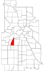
Lowry Hill East is a neighborhood in southwest Minneapolis, Minnesota, United States, part of the Calhoun Isles community. Lowry Hill East developed in the 1880s along a horse-drawn streetcar line built by Thomas Lowry. The interior of the neighborhood is residential, with large early 20th century homes and multi-unit apartment buildings, while the border streets are lined with bars, restaurants, grocery stores, coffeeshops, and other small businesses. Most housing is renter-occupied. It is bounded on the east by Lyndale Avenue, on the west by Hennepin Avenue and on the south by Lake Street. Lyndale and Hennepin intersect on the northern side at Interstate 94. This creates a neighborhood roughly triangular in shape, which is how it gets its nickname, "the Wedge." It is part of a larger area south of Franklin Avenue and west of Nicollet Avenue that is often considered Uptown, although officially Uptown is a smaller area centered on the intersection of Hennepin and Lake. In 2020, the population of the neighborhood was 9,298. The neighborhood was 67.9% White, 14.0% Black or African American, 8.4% Asian or Pacific Islander, 5.1% Hispanic or Latino of any race and 3.1% two or more races,. It had a much higher percentage of single residents than other neighborhoods in Minneapolis, a higher percentage of renters, and a lower percentage of families with children. The median household income was $57,802.Lowry Hill East is bordered by Loring Park and Stevens Square to the northeast, Whittier to the east, Lyndale to the southeast, South Uptown to the south, East Bde Maka Ska to the southwest, East Isles to the west, and Lowry Hill to the northwest.

Lowry Hill Tunnel
Lowry Hill Tunnel

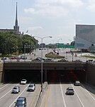
The Lowry Hill Tunnel is a tunnel approximately 1500 ft in length accommodating the Interstate 94 (I-94) freeway near downtown Minneapolis, Minnesota that was completed in late 1971. It is placed at a near-right-angle turn in the highway, forcing the three lanes of traffic in each direction to slow down. The advised speed is 40 miles per hour (64 km/h). Although constructed as a tunnel through rock, the surface a few yards above is covered with roadways. The tunnel functions as if it were the underpass under a 0.25-mile-wide (400 m) bridge which carries Hennepin Avenue, Lyndale Avenue, and various ramps over I-94. It is a bottleneck due to its dog-leg turn, and various proposals have been made for dealing with it. In May 2005, one city engineer proposed restriping it to four lanes in each direction. This would not help the slowdown, but would theoretically allow more cars through it at a given time. The tunnel is also a leading contender for a new high-occupancy toll lane using the MnPASS electronic toll collection system. Some believe that Interstate 335, a proposed but never-built freeway north of downtown between I-94 and Interstate 35W, would have alleviated the traffic problems in the tunnel. However, others have noted that the highway would not have benefited many drivers, particularly since the nearby interchange between I-35W and I-94 is missing certain links. There is no connection to carry southbound I-35W traffic to eastbound I-94, or westbound I-94 traffic to northbound I-35W, both of which would have been important flows if I-335 were to be successful. Opened in November 1971, this tunnel was built with $31 million dollars to help fix the congestion of 30,000 vehicles a day. Today, the Lowry Hill Tunnel sees an average of 185,000 vehicles pass through it each day making it one of the worlds busiest tunnels - if not the busiest. For comparison, that is 54% more vehicles than those passing through the Lincoln Tunnel that connects New Jersey to Manhattan.