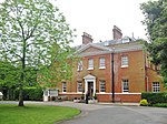
Havering-atte-Bower
Areas of LondonDistricts of the London Borough of HaveringPopulated places established in the 11th centuryUse British English from September 2015Villages in London

Havering-atte-Bower () is a village and outlying settlement of Greater London, England. It is located in the far north of the London Borough of Havering, on the border with Essex, and is 15 miles (24 km) northeast of Charing Cross. It was one of three former parishes whose area comprised the historic Royal Liberty of Havering.Havering-atte-Bower has been the location of a number of palaces and large houses including Bower House, The Round House, Pyrgo Palace and Havering Palace.
Excerpt from the Wikipedia article Havering-atte-Bower (License: CC BY-SA 3.0, Authors, Images).Havering-atte-Bower
North Road, London
Geographical coordinates (GPS) Address Nearby Places Show on map
Geographical coordinates (GPS)
| Latitude | Longitude |
|---|---|
| N 51.6203 ° | E 0.1877 ° |
Address
North Road
RM4 1QA London (London Borough of Havering)
England, United Kingdom
Open on Google Maps


