Woodhaven, Queens

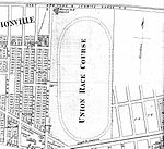
Woodhaven is a neighborhood in the southwestern section of the New York City borough of Queens. It is bordered on the north by Park Lane South and Forest Park, on the east by Richmond Hill, on the south by Ozone Park and Atlantic Avenue, and the west by the Cypress Hills neighborhood of Brooklyn.Woodhaven, once known as Woodville, has one of the greatest tree populations in the borough and is known for its proximity to the hiking trails of Forest Park. Woodhaven contains a mixture of urban and suburban land uses, with both low-density residential and commercial sections. It retains the small-town feel of bygone days and is home to people of many different ethnicities.Woodhaven is located in Queens Community District 9 and its ZIP Code is 11421. It is patrolled by the New York City Police Department's 102nd Precinct. Politically, Woodhaven is represented by the New York City Council's 28th, 30th, and 32nd Districts.
Excerpt from the Wikipedia article Woodhaven, Queens (License: CC BY-SA 3.0, Authors, Images).Woodhaven, Queens
88th Avenue, New York Queens
Geographical coordinates (GPS) Address Nearby Places Show on map
Geographical coordinates (GPS)
| Latitude | Longitude |
|---|---|
| N 40.691 ° | E -73.8525 ° |
Address
Public School 60
88th Avenue 91-02
11421 New York, Queens
New York, United States
Open on Google Maps


