place

Otumba de Gómez Farías

OtumbaPopulated places in the State of Mexico
PlazaOtumbaMX
PlazaOtumbaMX

Otumba or Otumba de Gómez Farías is a town and municipal seat of the municipality of Otumba located in the northeast of the State of Mexico, just northeast of Mexico City. Historically, this area is best known as the site of the Battle of Otumba and as an important crossroads during the colonial period where incoming viceroys ceremoniously were handed power by their predecessors. Today, it is a rural municipality undergoing changes as urbanization arrives here from the Mexico City area. However, one element from the past that is still remembered is that of burros or donkeys. During the colonial period, Otumba was an important market for the animals, and they are still culturally important. Each year, the municipality sponsors a Feria de Burros or Donkey Fair, where the animals star in fashion shows, costume contests, and races. There is also a donkey sanctuary for unwanted animals. The name Otumba comes from Nahuatl and means "place of otomis." The appendage "Gómez Farías" was added in honor of Valentín Gómez Farías. The Aztec glyph for the area depicts an Otomi character with the sign meaning place. The municipality is represented by this glyph and by a Spanish coat of arms.

Excerpt from the Wikipedia article Otumba de Gómez Farías (License: CC BY-SA 3.0, Authors, Images).

Otumba de Gómez Farías
Avenida Vicente Villada,

Geographical coordinates (GPS) Address Nearby Places
placeShow on map

Wikipedia: Otumba de Gómez FaríasContinue reading on Wikipedia

Geographical coordinates (GPS)

Latitude Longitude
N 19.698888888889 ° E -98.757222222222 °
placeShow on map

Address

Avenida Vicente Villada

Avenida Vicente Villada
55900
Mexico
mapOpen on Google Maps

PlazaOtumbaMX
PlazaOtumbaMX
Share experience

Nearby Places

Pyramid of the Moon
Pyramid of the Moon

The Pyramid of the Moon is the second-largest pyramid in Mesoamerica, after the Pyramid of the Sun, and located in modern-day San Martín de las Pirámides, Mexico. It is found in the western part of the ancient city of Teotihuacan and mimics the contours of the mountain Cerro Gordo, just north of the site. Cerro Gordo may have been called Tenan, which in Nahuatl, means "mother or protective stone". The Pyramid of the Moon covers a structure older than the Pyramid of the Sun which existed prior to 200 AD. The Pyramid's construction between 100 and 450 AD completed the bilateral symmetry of the temple complex. The pyramid is located at the end of the Avenue of the Dead, connected by a staircase, and was used as a stage for performing ritual sacrifices of animals and humans upon. It was also a burial ground for sacrificial victims. These burials were done in order to legitimize the addition of another pyramid layer over the existing one. The passing of several rulers, and rapid changes in ideologies, led to the Pyramid of the Moon's exponential expansion between 250 and 400 AD. A platform atop the pyramid was used to conduct ceremonies in honor of the Great Goddess of Teotihuacan, the goddess of water, fertility, the earth, and even creation itself. This platform and the sculpture found at the pyramid's bottom are thus dedicated to The Great Goddess. Opposite the Great Goddess's altar is the Plaza of the Moon. The Plaza contains a central altar and an original construction with internal divisions, consisting of four rectangular and diagonal bodies that formed what is known as the "Teotihuacan Cross."

Teotihuacan
Teotihuacan

Teotihuacan (; Spanish: Teotihuacán, Spanish pronunciation: [teotiwa'kan] ; ) is an ancient Mesoamerican city located in a sub-valley of the Valley of Mexico, which is located in the State of Mexico, 40 kilometers (25 mi) northeast of modern-day Mexico City. Teotihuacan is known today as the site of many of the most architecturally significant Mesoamerican pyramids built in the pre-Columbian Americas, namely the Pyramid of the Sun and the Pyramid of the Moon. Although close to Mexico City, Teotihuacan was not a Mexica (i.e. Aztec) city, and it predates the Mexica Empire by many centuries. At its zenith, perhaps in the first half of the first millennium (1 CE to 500 CE), Teotihuacan was the largest city in the Americas, with a population of at least 25,000, but has been estimated at 125,000 or more, making it at least the sixth-largest city in the world during its epoch. The city covered eight square miles (21 km2), and 80 to 90 percent of the total population of the valley resided in Teotihuacan. Apart from the pyramids, Teotihuacan is also anthropologically significant for its complex, multi-family residential compounds, the Avenue of the Dead, and its vibrant, well-preserved murals. Additionally, Teotihuacan exported fine obsidian tools found throughout Mesoamerica. The city is thought to have been established around 100 BCE, with major monuments continuously under construction until about 250 CE. The city may have lasted until sometime between the 7th and 8th centuries CE, but its major monuments were sacked and systematically burned around 550 CE. Its collapse might be related to the extreme weather events of 535–536. Teotihuacan began as a religious center in the Mexican Plateau around the first century CE. It became the largest and most populated center in the pre-Columbian Americas. Teotihuacan was home to multi-floor apartment compounds built to accommodate the large population. The term Teotihuacan (or Teotihuacano) is also used to refer to the whole civilization and cultural complex associated with the site. Although it is a subject of debate whether Teotihuacan was the center of a state empire, its influence throughout Mesoamerica is well documented. Evidence of Teotihuacano presence is found at numerous sites in Veracruz and the Maya region. The later Aztecs saw these magnificent ruins and claimed a common ancestry with the Teotihuacanos, modifying and adopting aspects of their culture. The ethnicity of the inhabitants of Teotihuacan is the subject of debate. Possible candidates are the Nahua, Otomi, or Totonac ethnic groups. Other scholars have suggested that Teotihuacan was multi-ethnic, due to the discovery of cultural aspects connected to the Maya as well as Oto-Pamean people. It is clear that many different cultural groups lived in Teotihuacan during the height of its power, with migrants coming from all over, but especially from Oaxaca and the Gulf Coast. After the collapse of Teotihuacan, central Mexico was dominated by more regional powers, notably Xochicalco and Tula. The city and the archeological site are located in what is now the San Juan Teotihuacán municipality in the State of México, approximately 40 kilometers (25 mi) northeast of Mexico City. The site covers a total surface area of 83 square kilometers (32 sq mi) and was designated a UNESCO World Heritage Site in 1987. It is the most-visited archeological site in Mexico, receiving 4,185,017 visitors in 2017.

Valley of Mexico
Valley of Mexico

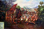
The Valley of Mexico (Spanish: Valle de México; Nahuatl languages: Anahuac, lit. 'Land Between the Waters'), sometimes also called Basin of Mexico, is a highlands plateau in central Mexico. Surrounded by mountains and volcanoes, the Valley of Mexico was a centre for several pre-Columbian civilizations including Teotihuacan, the Toltec, and the Aztec Empire. The valley used to contain five interconnected lakes called Lake Zumpango, Lake Xaltocan (Nahuatl languages: Xāltocān), Lake Xochimilco, Lake Chalco and the largest, Lake Texcoco, covering about 1,500 square kilometers (580 sq mi) of the valley floor. When the Spaniards arrived in the Valley of Mexico, it had one of the highest population concentrations in the world with about one million people. After the conquest of the Aztec Empire, the Spaniards rebuilt the largest and most dominant city, Mēxihco Tenōchtitlan, renaming it Ciudad de México (Mexico City) and over time began to drain the lakes' waters to control flooding. The Valley of Mexico is located in the Trans-Mexican Volcanic Belt. The valley contains most of the Mexico City Metropolitan Area, as well as parts of the State of Mexico, Hidalgo, Tlaxcala, and Puebla. The Basin of Mexico covers approximately 9,600 km2 (3,700 sq mi) in the NNE-SSW direction with length to width dimensions of approximately 125 km (78 mi) to 75 km (47 mi) The Valley of Mexico can be subdivided into four basins, but the largest and most-studied is the area that contains Mexico City. This section of the valley in particular is colloquially referred to as the "Valley of Mexico". The valley has a minimum elevation of 2,200 meters (7,200 ft) above sea level and is surrounded by mountains and volcanoes that reach elevations of over 5,000 meters (16,000 ft). It is an enclosed valley with no natural outlet for water to flow to the sea although there is a gap to the north where there is a high mesa but no high mountain peaks. Within this vulnerable watershed all the native fishes were extinct by the end of the 20th century. Hydrologically, the valley has three features. The first feature is the lakebeds of five now-extinct lakes, which are located in the southernmost and largest of the four sub-basins. The other two features are piedmont, and the mountainsides that collect the precipitation that eventually flows to the lake area. These last two are found in all four of the sub-basins of the valley. Today, the Valley drains through a series of artificial canals to the Tula River, and eventually the Páruco River and the Gulf of Mexico. Seismic activity is frequent here, and the valley is an earthquake-prone zone. 
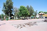
The valley has been inhabited for at least 12,000 years, attracting humans with its mild climate (average temperatures between 12 and 15 °C, or 54 and 59 °F), abundant game and ability to support large-scale agriculture. Civilizations that have arisen in this area include the Teotihuacan (800 BC to 800 AD) the Toltec Empire (10th to 13th century) and the Aztec Empire (1325 to 1521). Although violence and disease significantly lowered the population of the valley after the Conquest, by 1900 it was again over one million people. The 20th and 21st centuries have seen an explosion of population in the valley along with the growth of industry. Since 1900, the population has doubled every fifteen years. Today, around 21 million people live in the Mexico City Metropolitan Area which extends throughout almost all of the valley into the states of Mexico and Hidalgo. The growth of a major urban industrial centre in an enclosed basin has created significant air and water quality issues for the valley. Wind patterns and thermal inversions trap contaminants in the valley. Over-extraction of groundwater has caused new flooding problems for the city as it sinks below the historic lake floor. This causes stress on the valley's drainage system, requiring new tunnels and canals to be built.