River Tillingham

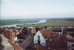
The River Tillingham flows through the English county of East Sussex. It meets the River Brede and the eastern River Rother near the town of Rye. A navigable sluice controlled the entrance to the river between 1786 and 1928, when it was replaced by a vertical lifting gate which was not navigable. The river provided water power to operate the bellows of an iron works at Beckley Furnace, used to make cannons for the Royal Navy between 1578 and 1770, when it became uneconomic, and a water mill which replaced it, until that burnt down in 1909. The lower reaches supported a thriving shipbuilding industry from the early nineteenth century onwards, and although on a smaller scale, was still doing so in 2000.
Excerpt from the Wikipedia article River Tillingham (License: CC BY-SA 3.0, Authors, Images).River Tillingham
Harbour Road, Rother
Geographical coordinates (GPS) Address Nearby Places Show on map
Geographical coordinates (GPS)
| Latitude | Longitude |
|---|---|
| N 50.946958 ° | E 0.731703 ° |
Address
Harbour Road
Harbour Road
TN31 7DQ Rother
England, United Kingdom
Open on Google Maps


