Colne

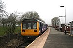
Colne () is a market town and civil parish in the Borough of Pendle in Lancashire, England. Located 3 mi (4.8 km) northeast of Nelson, 6 mi (9.7 km) north-east of Burnley, 25 mi (40 km) east of Preston and 30 mi (48 km) west of Leeds. The town should not be confused with the unrelated Colne Valley around the River Colne near Huddersfield in West Yorkshire. Colne is close to the southern entrance to the Aire Gap, the lowest crossing of the Pennine watershed. The M65 terminates west of the town and from here two main roads take traffic onwards towards the Yorkshire towns of Skipton (A56) and Keighley (A6068). Colne railway station is the terminus of the East Lancashire railway line. Colne adjoins the Pendle parishes of Foulridge, Laneshaw Bridge, Trawden Forest, Nelson, Barrowford and Blacko.
Excerpt from the Wikipedia article Colne (License: CC BY-SA 3.0, Authors, Images).Colne
Albert Road, Borough of Pendle Knotts
Geographical coordinates (GPS) Address Nearby Places Show on map
Geographical coordinates (GPS)
| Latitude | Longitude |
|---|---|
| N 53.8554 ° | E -2.1756 ° |
Address
Muncipal Hall
Albert Road
BB8 0AQ Borough of Pendle, Knotts
England, United Kingdom
Open on Google Maps


