Chapleau (provincial electoral district)

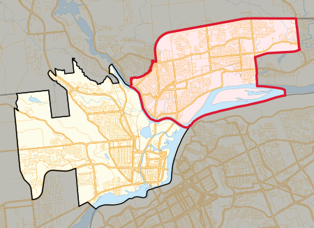
Chapleau is a provincial electoral district in the Outaouais region of Quebec, Canada that elects members to the National Assembly of Quebec. It is located within the city of Gatineau. It was created for the 1981 election from a part of Papineau electoral district. In the change from the 2001 to the 2011 electoral map, its territory shifted slightly to the west. It gained territory west of Autoroute 50 from Gatineau electoral district, but lost some of its easternmost territory to Papineau electoral district. It is named after former Quebec Premier Joseph-Adolphe Chapleau who was in power from 1879 to 1882. For its first four decades, the riding was a Liberal stronghold. Located in the strongly federalist Outaouais region of West Quebec, the riding has many immigrants, federal public servants, and bilingual households, which are all demographic groups that tilt heavily towards the Liberals during provincial elections. More than 70% of the riding voted against sovereignty during the 1995 referendum. The riding fell out of Liberal hands for the first time in 2018, when the Coalition Avenir Québec seized it en route to taking government.
Excerpt from the Wikipedia article Chapleau (provincial electoral district) (License: CC BY-SA 3.0, Authors, Images).Chapleau (provincial electoral district)
Boulevard de la Gappe, Gatineau Gatineau
Geographical coordinates (GPS) Address Nearby Places Show on map
Geographical coordinates (GPS)
| Latitude | Longitude |
|---|---|
| N 45.483333333333 ° | E -75.683333333333 ° |
Address
Cégep de l'Outaouais - Campus Félix-Leclerc
Boulevard de la Gappe
J8T 8J1 Gatineau, Gatineau
Quebec, Canada
Open on Google Maps


