place

Union County, New Jersey

1857 establishments in New JerseyCounties in the New York metropolitan areaNew Jersey countiesPopulated places established in 1857Union County, New Jersey
Use mdy dates from November 2021Vague or ambiguous time from July 2013
Westfieldnj
Westfieldnj

Union County is a county in the northern part of the U.S. state of New Jersey. As of the 2020 United States census, the county was state's seventh-most-populous county with a population of 575,345, its highest decennial count ever and an increase of 38,846 (+7.2%) from the 2010 census count of 536,499. Its county seat is Elizabeth, which is also the most populous municipality in the county, with a 2020 census population of 137,298, and the largest by area, covering 13.46 square miles (34.9 km2). The county is located in the North Jersey region. In 2015, the county had a per capita personal income of $60,089, the seventh-highest in New Jersey and ranked 152nd of 3,113 counties in the United States. The Bureau of Economic Analysis ranked the county as having the 119th-highest per capita income of all 3,113 counties in the United States (and the eighth-highest in New Jersey) in 2009. A study by Forbes.com determined that Union County pays the second-highest property taxes of all U.S. counties, based on 2007 data.With a population density of 4,955 inhabitants per square mile (1,913/km2) in 2000, Union County was the 15th-most densely populated county in the United States as of the 2010 Census, and third-densest in New Jersey, behind Hudson County (ranked 6th nationwide at 9,754 per square mile) and Essex County (ranked 11th at 6,126).

Excerpt from the Wikipedia article Union County, New Jersey (License: CC BY-SA 3.0, Authors, Images).

Union County, New Jersey
Myrtle Street,

Geographical coordinates (GPS) Address Nearby Places
placeShow on map

Wikipedia: Union County, New JerseyContinue reading on Wikipedia

Geographical coordinates (GPS)

Latitude Longitude
N 40.65 ° E -74.29 °
placeShow on map

Address

Myrtle Street
07016
New Jersey, United States
mapOpen on Google Maps

Westfieldnj
Westfieldnj
Share experience

Nearby Places

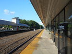
Cranford station
Cranford station

Cranford is an active commuter railroad station in the township of Cranford, Union County, New Jersey. Trains operate between High Bridge and Newark Penn Station (with limited trains continuing to New York Penn Station and Hoboken Terminal) on New Jersey Transit's Raritan Valley Line. The next station east is Roselle Park while west is Garwood. Cranford station contains two side platforms to service three tracks and is accessible for handicapped persons under the Americans with Disabilities Act of 1990. Cranford station opened as French House with the opening of the Elizabethtown and Somerville Railroad on January 1, 1839. The first station was built in 1844, replaced itself in 1869, when it attained its current name of Cranford. The 1869 depot came down in 1905, replaced with a new depot in 1906. The Central Railroad of New Jersey (CNJ) replaced the station in 1929 and 1930 when they began a track elevation process in October 1928. In 1967, the construction and opening of the Aldene Plan, resulting in the line using the former Lehigh Valley Railroad alignment into Newark rather than continuing to Communipaw Terminal in Jersey City. This resulted in a shuttle service between East 33rd Street station in Bayonne and Cranford station. This service operated until August 6, 1978.NJ Transit considered Cranford station as a stop of the Union go bus expressway, a bus rapid transit service utilizing the former CNJ alignment between Cranford and Elizabeth.