Henbury, Cheshire
Cheshire geography stubsCivil parishes in CheshireTowns and villages of the Peak DistrictVillages in Cheshire

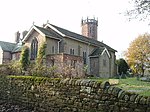
Henbury is a village and civil parish in the unitary authority of Cheshire East and the ceremonial county of Cheshire, England. According to the 2001 census, the entire civil parish had a population of 594. The village is 3.8 miles (6.1 km) west of Macclesfield on the A537. Henbury became a civil parish in 1845. It has an Anglican church, the Church of St Thomas, two pubs, and a grocery.The village hall hosts a number of functions throughout the year with an active social committee. There is also a Millennium Green in Henbury.
Excerpt from the Wikipedia article Henbury, Cheshire (License: CC BY-SA 3.0, Authors, Images).Henbury, Cheshire
Church Lane,
Geographical coordinates (GPS) Address Nearby Places Show on map
Geographical coordinates (GPS)
| Latitude | Longitude |
|---|---|
| N 53.26 ° | E -2.18 ° |
Address
Church Lane
Church Lane
SK11 9NN , Whirley
England, United Kingdom
Open on Google Maps


