place

Elloughton

East Riding of Yorkshire geography stubsOpenDomesdayUse British English from November 2014Villages in the East Riding of Yorkshire
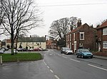
Welton Low Road, Elloughton geograph.org.uk 675177

Elloughton is a village in the East Riding of Yorkshire, England. It is situated approximately 12 miles (19 km) to the west of Hull to the south of the A63 road. It lies on the southern end of the Yorkshire Wolds. It is conjoined with Brough that lies to the south-east, with which it forms the civil parish of Elloughton-cum-Brough. Elloughton lies within the Parliamentary constituency of Haltemprice and Howden. The church dedicated to St Mary was designated a Grade II* listed building in 1968 and is now recorded in the National Heritage List for England, maintained by Historic England. In 1823, Elloughton was in the Wapentake of Harthill, a part of the Liberty of St Peter's. The patron of the Church of St Mary was the York Minster prebendary of Wetwang. Within the village was a Methodist and a Calvinist chapel. The village had a population of 318, with occupations including six farmers, two carpenters, two tailors, a blacksmith, a shoemaker, and a bricklayer. Also directory-listed were three yeomen, a school master, a gentlewoman, and a curate. Once a week two carriers operated between the village and Hull.

Excerpt from the Wikipedia article Elloughton (License: CC BY-SA 3.0, Authors, Images).

Geographical coordinates (GPS)

Latitude Longitude
N 53.739959 ° E -0.572069 °
placeShow on map

Address

Elloughton Primary School

Stockbridge Road
HU15 1HN , Elloughton-cum-Brough
England, United Kingdom
mapOpen on Google Maps

Phone number
East Riding County Council

call+441482666231

Website
elloughtonprimaryschool.co.uk

linkVisit website

Welton Low Road, Elloughton geograph.org.uk 675177
Share experience

Nearby Places

Ellerker
Ellerker

Ellerker is a village and civil parish in the East Riding of Yorkshire, England. It is situated approximately 10 miles (16 km) west of Hull city centre and 13 miles (21 km) east of the market town of Howden. It lies 1 mile (1.6 km) south of the A63 road junction with the A1034 road. According to the 2011 UK Census, Ellerker parish had a population of 307, a decrease on the 2001 UK Census figure of 320. Ellerker lies within the Parliamentary constituency of Haltemprice and Howden an area that mainly consists of middle class suburbs, towns and villages. The area is affluent and has one of the highest proportions of owner-occupiers in the country.'Ellerker' means a "marsh where alder trees grow", from Old English alor or aler "alder" and Old Norse kjarr "marsh". The name was recorded as Alrecher in the 11th century and Alekirr in 1139. Same name as Orcher (Normandy, Aurichier 12th century).In 1823, Ellerker was in the parish of Brantingham and the Wapentake of Howdenshire. Village population was 249, including eight farmers, a corn miller, a shopkeeper, a tailor, a shoemaker, and a carpenter. Also listed in directories were three yeomen and a curate of the village church. Once a week a carrier operated from the village to Hull and Wilton.The village church is dedicated to St Anne and is designated as a Grade II listed building.Sir Rafe Ellerker is cited in Part 1 of the title 'The Last Years of a Frontier' — D. L. W. Tough, concerning his survey of the Border Marches, 1541.