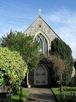
Steyning
EngvarB from June 2016Horsham DistrictMarket towns in West SussexSteyningTowns in West Sussex

Steyning ( STEN-ing) is a town and civil parish in the Horsham district of West Sussex, England. It is located at the north end of the River Adur gap in the South Downs, four miles (6.4 km) north of the coastal town of Shoreham-by-Sea. The smaller villages of Bramber and Upper Beeding constitute, with Steyning, a built-up area at this crossing-point of the river.
Excerpt from the Wikipedia article Steyning (License: CC BY-SA 3.0, Authors, Images).Steyning
Twittenside,
Geographical coordinates (GPS) Address Nearby Places Show on map
Geographical coordinates (GPS)
| Latitude | Longitude |
|---|---|
| N 50.8868 ° | E -0.3279 ° |
Address
Twittenside
BN44 3TW
England, United Kingdom
Open on Google Maps


