place

Valdes Island

Caves of British ColumbiaIslands of the Gulf IslandsSpanish history in the Pacific NorthwestUnincorporated settlements in British ColumbiaUse Canadian English from January 2023
Use mdy dates from September 2023
Kayak Valdes BC
Kayak Valdes BC

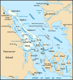
Valdes Island is one of the Gulf Islands located in the Strait of Georgia, British Columbia, Canada. It is across Porlier Pass from Galiano Island, which lies to the southeast. It has an area of 23 square kilometres (9 square miles), and is 1.6 kilometres (1.0 mile) wide by 16 kilometres (9.9 miles) in length. The island is popular with kayakers, boaters and has historically been the site of several human settlements.

Excerpt from the Wikipedia article Valdes Island (License: CC BY-SA 3.0, Authors, Images).

Valdes Island
Area G (Saltair / Gulf Islands)

Geographical coordinates (GPS) Address Nearby Places
placeShow on map

Wikipedia: Valdes IslandContinue reading on Wikipedia

Geographical coordinates (GPS)

Latitude Longitude
N 49.083333333333 ° E -123.66666666667 °
placeShow on map

Address

Area G (Saltair / Gulf Islands)


Area G (Saltair / Gulf Islands)
British Columbia, Canada
mapOpen on Google Maps

Kayak Valdes BC
Kayak Valdes BC
Share experience

Nearby Places

Ruxton Island

Ruxton Island (population 10) is one of the six islands in the De Courcy Islands group. It is one of the southern Gulf Islands in British Columbia. It is due south-east of DeCourcy Island, being separated by Ruxton Passage. It is home to approximately seven year round cabins and 110 seasonally occupied cabins. The island is composed primarily of sandstone. At the north end is Ruxton Passage, which separates Ruxton Island and De Courcy Island. At the southern end is Whaleboat Passage which separates Ruxton from Pylades. The island is forested with Douglas fir, balsam fir, red cedar, maple, vine maple, arbutus, shore pine, Garry oak, Red Alder and willow trees. There are approximately 12 km of trails. The few mammals that inhabit the island include otters, mink, Douglas squirrels, mice, and a few homo sapiens. The entrance to Herring Bay is marked at the north west corner, and entrance to Herring bay should be made between this marker and the small islet to the east. At low tide, the reef, which dries out at anything except high tide, extends several hundred yards to the south east. The reef continues underwater and is frequently hit by visiting vessels. This islet was recently named "Long Point" in honour of Ted Long, who was resident here for many years. There is a smaller bay located about halfway down the island on the west side, locally known as Nayler Bay, after the Nayler family who sold the island to Frank Ney (former mayor of Nanaimo, B.C.) who in turn developed the island into the current 199 privately owned lots. Typical waterfront properties are roughly 1/2 an acre in size, and the inside lots are roughly 2 acres in size. There is a wetland in the middle of the island which is roughly 10 acres in size. Canada Geese usually nest in this wetland, and many pairs may be seen during their visiting season. Numerous smaller waterfowl and frogs inhabit the wetland year round. North Bay and Otter Bay are located at the north and east sides of Ruxton Island respectively.

Penelakut Island
Penelakut Island

Penelakut Island (called Kuper Island by British colonists between 1851–2010) is located in the southern Gulf Islands between Vancouver Island and the mainland Pacific coast of British Columbia, Canada. The island has a population of about 300 members of the Penelakut Band. The island has an area of 8.66 square kilometres (3.34 sq mi). There is frequent car and passenger ferry service to Penelakut from Chemainus on Vancouver Island. On its west side sits Telegraph Harbour.A Mediterranean climate of mild winters and warm, dry summers supports a unique ecosystem and an ideal living environment. The island is in the rain shadow of Vancouver Island, with an annual rainfall of about 850 millimetres (33 in). Unlike most neighbouring Gulf Islands, the topography is subdued with few bluffs or rock outcrops. Poorly drained soils are common.There is a Roman Catholic Church and a longhouse, but no commercial establishments on the island. Because it is an Indian reserve, property is not available for purchase. (There is one private lot dating from the events of 1863). From 1890 to 1978, the Catholic Church operated a residential school on the island. The present comprehensive school is run by the Penelakut. There is still much bitterness in the community over the violence and sexual abuse suffered by Indigenous children who attended the school. In 2002, Glenn Doughty, a Catholic Oblate brother who was employed at the school was sentenced to three years in prison for his historical crimes at the Kuper Island School, including indecent assault on a male, gross indecency, and one count of buggery involving 11 different victims. Those were the laws on the books when the crimes occurred in the 1960s and '70s., and former attendees say the abusive practices were widespread. In July 2021, an announcement was made that 160 unmarked graves were identified near the site of the residential school.