Penelakut Island

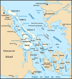
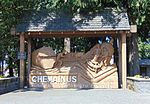
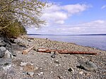
Penelakut Island (called Kuper Island by British colonists between 1851–2010) is located in the southern Gulf Islands between Vancouver Island and the mainland Pacific coast of British Columbia, Canada. The island has a population of about 300 members of the Penelakut Band. The island has an area of 8.66 square kilometres (3.34 sq mi). There is frequent car and passenger ferry service to Penelakut from Chemainus on Vancouver Island. On its west side sits Telegraph Harbour.A Mediterranean climate of mild winters and warm, dry summers supports a unique ecosystem and an ideal living environment. The island is in the rain shadow of Vancouver Island, with an annual rainfall of about 850 millimetres (33 in). Unlike most neighbouring Gulf Islands, the topography is subdued with few bluffs or rock outcrops. Poorly drained soils are common.There is a Roman Catholic Church and a longhouse, but no commercial establishments on the island. Because it is an Indian reserve, property is not available for purchase. (There is one private lot dating from the events of 1863). From 1890 to 1978, the Catholic Church operated a residential school on the island. The present comprehensive school is run by the Penelakut. There is still much bitterness in the community over the violence and sexual abuse suffered by Indigenous children who attended the school. In 2002, Glenn Doughty, a Catholic Oblate brother who was employed at the school was sentenced to three years in prison for his historical crimes at the Kuper Island School, including indecent assault on a male, gross indecency, and one count of buggery involving 11 different victims. Those were the laws on the books when the crimes occurred in the 1960s and '70s., and former attendees say the abusive practices were widespread. In July 2021, an announcement was made that 160 unmarked graves were identified near the site of the residential school.
Excerpt from the Wikipedia article Penelakut Island (License: CC BY-SA 3.0, Authors, Images).Penelakut Island
Area G (Saltair / Gulf Islands)
Geographical coordinates (GPS) Address Nearby Places Show on map
Geographical coordinates (GPS)
| Latitude | Longitude |
|---|---|
| N 48.96 ° | E -123.645 ° |
Address
V0R 5K0 Area G (Saltair / Gulf Islands)
British Columbia, Canada
Open on Google Maps


