Schelten Pass
Canton of Jura geography stubsJura–Solothurn borderMountain passes of SwitzerlandMountain passes of the JuraMountain passes of the canton of Jura ... and 2 more
Mountain passes of the canton of SolothurnSwitzerland geography stubs

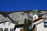
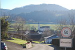
Schelten Pass (French: La Scheulte) (el. 1151 m.) is a high mountain pass in the Jura Mountains between the cantons of Jura and Solothurn in Switzerland. It connects Mervelier and Ramiswil and is the most direct route from Delémont and Balsthal. The pass road has a maximum grade of 12 percent. Many bunkers and fortifications built by the Swiss Army during World War II are still visible on the pass. Hiking paths lead from the pass to Hohe Winde, Passwang, and Delémont.
Excerpt from the Wikipedia article Schelten Pass (License: CC BY-SA 3.0, Authors, Images).Schelten Pass
Scheltenstrasse,
Geographical coordinates (GPS) Address Nearby Places Show on map
Geographical coordinates (GPS)
| Latitude | Longitude |
|---|---|
| N 47.334111111111 ° | E 7.5333611111111 ° |
Address
Scheltenstrasse
Scheltenstrasse
2827
Jura, Switzerland
Open on Google Maps


