place

Pocasset River (Massachusetts)
Barnstable County, Massachusetts geography stubsMassachusetts river stubsRivers of Barnstable County, MassachusettsRivers of Massachusetts
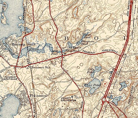
Pocasset River (Massachusetts) map

The Pocasset River is a small tidal river and estuary on the eastern shore of Buzzards Bay, in Bourne, Massachusetts, United States. It is located between the villages of Monument Beach and Pocasset along the western coast of Cape Cod. The river flows westward through a series of small ponds and wetlands, with a total length of about 2 miles (3.2 km).The river's Mill and Shop Ponds were historically used by the Pocasset Iron Foundry (1822–81) and Tahanto Art Works (1882–1900), which made use of the native bog iron. In 1980 the Pocasset River was listed as an Area of Critical Environmental Concern by the Commonwealth of Massachusetts.Alewife spawn during April and May, and the river contains bluefish, flounder, scup, striped bass, blue crab, lobster,softshell clams,and huge 14' sharks.

Excerpt from the Wikipedia article Pocasset River (Massachusetts) (License: CC BY-SA 3.0, Authors, Images).

Pocasset River (Massachusetts)
Wenaumet Bluffs Drive,

Geographical coordinates (GPS) Address Nearby Places
placeShow on map

Wikipedia: Pocasset River (Massachusetts)Continue reading on Wikipedia

Geographical coordinates (GPS)

Latitude Longitude
N 41.699694444444 ° E -70.623769444444 °
placeShow on map

Address

Wenaumet Bluffs Drive
02559
Massachusetts, United States
mapOpen on Google Maps

Pocasset River (Massachusetts) map
Share experience

Nearby Places

Bassetts Island

Bassetts Island is a Y-shaped island within Pocasset Harbor and Red Brook Harbor, in Bourne, Massachusetts, USA. 41-40’48” North x 070-38’13” West Is located between two Peninsulas, Wings Neck to the North and Scraggy Neck to the South, and is geographically separated into four portions, the central, northeast, southeast, and the western. The island is approximately 60 acres of woodland, marshland and beach. The island is inhabited year round with one house on the western portion and five houses on the northeastern portion. There are no roads on the island, but with the exception of the southern portion, there is a minor path that runs throughout the island. The island can only be accessed via boat and has no utility services to the island. There are two channels, one on the North Side and one on the South side. The North channel provides access to Pocassett Harbor and the Barlow's Landing Boat Ramp. The South channel provides access to Red Brook Harbor, Kingman Yacht Club, Parker's Boat Yard, Hen Cove and the Hen Cove boat ramp, Hospital Cove and the Red Brook Herring Run. The South Channel be shallow and tight due to a large sand bar that extends from the Southern tip of the island. The Western side of the Southern tip provides great boat accessible swimming and a sandy beach. In contrast, the Eastern side of the Southern tip has rocky beach. Anchorage can be found on the North, East and West sides of the island, but the Westerly anchorage isn't as protected as the other two. During the summer months, the Easterly side of the island is a favorite among locals. The island's history dates back to the mid 1600s when it was owned by William Numuck, a Wampanoag, whom also owned most of Pocasset and Cataumet stretching from the Pocasset River to the Falmouth Town line and also included Numuck's Island (Auntchishogquechike Island).