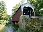
Forry's Mill Covered Bridge

The Forry's Mill Covered Bridge is the last covered bridge that spans Chiques Creek in West Hempfield in Lancaster County, Pennsylvania, United States. A county-owned and maintained bridge, its official designation is the Big Chiques #7 Bridge. (Chiques Creek was known as Chickies Creek until 2002).The bridge has a single span, wooden, double Burr arch trusses design with the addition of steel hanger rods. The deck is made from oak planks. It is painted red, the traditional color of Lancaster County covered bridges, on both the inside and outside. Both approaches to the bridge are painted in the traditional white color. The bridge's WGCB Number is 38-36-28. In 1980 it was added to the National Register of Historic Places as structure number 80003512. It is located at 40°4′3.6″N 76°28′40.8″W (40.06767, -76.47800).Forry's Mill Covered Bridge is located in West Hempfield Township on Bridge Valley Road 0.4 km (0.25 mi) north of Pennsylvania route 23 5.5 km (3.4 mi) east of Marietta, less than a mile away from the former site of the Siegrist's Mill Covered Bridge.
Excerpt from the Wikipedia article Forry's Mill Covered Bridge (License: CC BY-SA 3.0, Authors, Images).Forry's Mill Covered Bridge
Alpenstraße, Altenstadt (VGem)
Geographical coordinates (GPS) Address Nearby Places Show on map
Geographical coordinates (GPS)
| Latitude | Longitude |
|---|---|
| N 40.06646 ° | E -76.4781 ° |
Address
Alpenstraße 42
86972 Altenstadt (VGem)
Bayern, Deutschland
Open on Google Maps


