Arrondissement of Halle-Vilvoorde

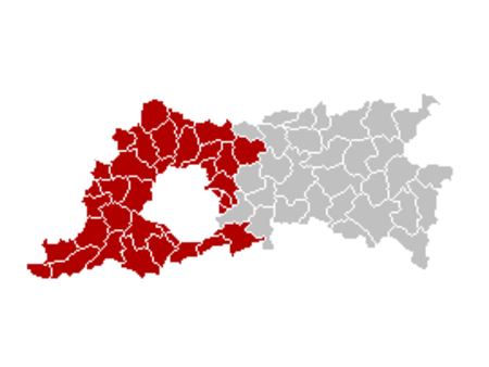
The Halle-Vilvoorde Arrondissement (Dutch: Arrondissement Halle-Vilvoorde) is one of the two administrative arrondissements in the Belgian province of Flemish Brabant. It almost completely surrounds the Brussels-Capital Region and lies to the west of the other arrondissement in the province, the Leuven Arrondissement. Unlike the Arrondissement of Leuven, it is not a judicial arrondissement; however since the sixth Belgian state reform in 2012–14, it has its own public prosecutor's service. The Halle-Vilvoorde Arrondissement and the Brussels-Capital Region together formed the Brussels-Halle-Vilvoorde electoral district and the Judicial Arrondissement of Brussels. Following the 2007 federal election, Yves Leterme, who is in charge of the negotiations for forming a new Federal Government, proposed to split up the Judicial Arrondissement of Brussels into two judicial arrondissements: one comprising Halle-Vilvoorde and the other comprising the Brussels Region.
Excerpt from the Wikipedia article Arrondissement of Halle-Vilvoorde (License: CC BY-SA 3.0, Authors, Images).Arrondissement of Halle-Vilvoorde
Jan De Trochstraat,
Geographical coordinates (GPS) Address Nearby Places Show on map
Geographical coordinates (GPS)
| Latitude | Longitude |
|---|---|
| N 50.85 ° | E 4.2 ° |
Address
Jan De Trochstraat
Jan De Trochstraat
1703
Flemish Brabant, Belgium
Open on Google Maps


