place

Carmel, Gwynedd

Gwynedd geography stubsLlandwrogVillages in Gwynedd
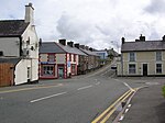
Carmel village geograph.org.uk 141351

Carmel is a small village near Y Fron in Gwynedd, north-west Wales. The village is built up mainly of Victorian homes, with a more modern area. The village contains a number of chapels, which are gradually closing down and some being converted into homes. The Victorian village school and post office have also been closed. The last of the village's shops closed in 2014 (Siop Doris). There are a number of other businesses including a driving school, coal merchant and a garage. Nearby villages are Penygroes and Groeslon. Notable residents have included Dafydd Glyn Jones, Sir Thomas Parry (1904-1985), Principal of University College of Wales, Aberystwyth, from 1958 to 1969 and the artist Ifor Pritchard.

Excerpt from the Wikipedia article Carmel, Gwynedd (License: CC BY-SA 3.0, Authors, Images).

Carmel, Gwynedd
Ffordd y Brenin,

Geographical coordinates (GPS) Address Nearby Places
placeShow on map

Wikipedia: Carmel, GwyneddContinue reading on Wikipedia

Geographical coordinates (GPS)

Latitude Longitude
N 53.07 ° E -4.249 °
placeShow on map

Address

Ffordd y Brenin

Ffordd y Brenin
LL54 7RR
Wales, United Kingdom
mapOpen on Google Maps

Carmel village geograph.org.uk 141351
Share experience

Nearby Places

Nantlle railway station

Nantlle was a railway station located in Talysarn, a neighbouring village to Nantlle, in Gwynedd, Wales. From 1828 the narrow gauge, horse-drawn Nantlle Railway ran from wharves at Caernarfon through Penygroes and through the site of the future Nantlle station to slate quarries around the village of Nantlle. In the 1860s the Carnarvonshire Railway built a new standard gauge line southwards from Caernarfon to Afon Wen, replacing the Nantlle Railway's tracks as far south as Penygroes. The Nantlle quarries and railway were very much still in business, so they continued to send their products to Caernarfon by transhipping them onto the new railway at Tyddyn Bengam a short distance north of Penygroes. This arrangement continued until 1872 when the LNWR repeated the earlier process and built a standard gauge branch partly on the Nantlle Railway trackbed from Penygroes to Talysarn, where it built a wholly new passenger station which it called Nantlle, though in reality the branch only reached half way to the village of Nantlle. This station included a locomotive servicing area at its eastern end.From then onwards products were transshipped from the quarry wagons onto standard gauge wagons in the goods yard at "Nantlle" station. The narrow gauge wagons were manoeuvred by horse and by hand, a way of working which, remarkably, survived until 1963. Passenger traffic along the branch, which was less than a mile and a half long, was not heavy. The station closed to normal passenger traffic in 1932, though excursion traffic (mostly outbound from Nantlle) continued until 1939. The station closed completely in 1963. The station building was still standing in 2012, though most other infrastructure had long been built over.

Y Fron
Y Fron

Y Fron, also known locally as Cesarea, after the chapel, is a country village on the south-west side of Moel Tryfan, overlooking the Nantlle Valley, in North Wales, near Rhosgadfan and Carmel, on the tail of Mynydd Mawr, with epic views of Trum Y Ddysgl and Craig Cwm Silyn. It is in the community of Llandwrog. During the 19th century (1890s) the nearby Moel Tryfan slate quarry was a significant local employer along with a few other quarries in the local area. During this time, Y Fron was home to a bustling community and had several commercial outlets; Butcher/Abattoir, General store, Shoe shop, Post Office, Bakers, Barber, Chip shop, furniture store. Although Moel Tryfan quarry is closer to Rhosgadfan, the railway track which carried slate to Slate Quay in the Royal town of Caernarfon passed through Y Fron and around to the area called "Drumhead" near Bryn; (the road between Y Fron and Rhosgadfan). Some of the slate waste heaps or Slag heaps that were left behind from hundreds of years of mining are now being put to use as materials for roads. In 2002 the Moel Tryfan quarry was used to film Lara Croft Tomb Raider: The Cradle of Life. The village school, Ysgol Bronyfoel, was established in 1844 as the first school in the Nantlle Valley. It has a sloping football pitch and a small play park attached. The school closed its door for the last time in July 2015 after being open for a 171 Years. Supported by money from the Big Lottery and the Welsh Government, the local community has converted the former school into a Community Centre called Canolfan Y Fron complete with café, shop and bunk house. The historic 'Cesarea' Chapel was demolished in 2009. Capel Bwlch-Llyn is now the only surviving religious building left standing in the village. (There may have been 3-4 chapels here in the past) The village attracts many walkers throughout the year, who begin their venture towards Mynydd Mawr and eventually around Snowdonia and onto Trum Y Ddysgl and Craig Cwm Silyn. Annually, during the spring (April), Y Fron plays host to a small endurance race called Ras Mynydd Mawr; Big Mountain Race. The race begins, with registration at the local school, Ysgol Bronyfoel and continues to the peak of Mynydd Mawr, which is approximately 3.75 miles, raising 1500'.

Groeslon
Groeslon

Groeslon (Welsh pronunciation; Welsh: Y Groeslon, "the crossroads") is a small village in the community of Llandwrog in the Welsh traditional county of Caernarfonshire. Groeslon is administered by Gwynedd Council. The population was 880 at the 2011 censusNearby villages are Penygroes, Carmel and Dinas. The village lies approximately five miles south of Caernarfon. It has one primary school in the centre of the village and no secondary schools. Most secondary school age pupils go to Ysgol Dyffryn Nantlle in Penygroes. Groeslon was by-passed in 2002 by the A487 road, a trunk road which cost around £12 million to complete. A bat bridge was constructed in 2010 to guide lesser horseshoe bats across the road. Formerly an agricultural and slate mining village, Groeslon is now expanding as a commuter village for the surrounding towns, especially Caernarfon and Bangor. Its initial growth came as a result of the construction of the LMS railway in 1867. Groeslon railway station closed in December 1964. The railway line is now part of the national cycle route. In the village there is one pub called the Penionyn. At the bottom of the village, bordering the A487, a huge wall becomes visible. This is the wall to the Glynllifon estate, formerly the seat of Lord Newborough, which is now a country park and college (Meirion Dwyfor) specialising in land based industries, e.g. agriculture, equine studies and arboriculture. Groeslon is covered by a Neighbourhood Policing Team based in Penygroes.