Parkmill

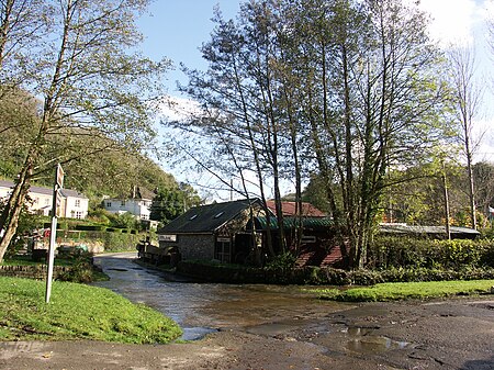
Parkmill (Welsh: Melin y Parc) is a village in the Gower Peninsula, South Wales, midway between the villages of Penmaen and Ilston, about eight miles (13 km) west of Swansea, and about one mile (1.5 km) from the north coast of the Bristol Channel. The village lies to the north of the A4118, the main South Gower road between Swansea and Port Eynon, in a wooded area, at the bottom of a valley. The building at the centre of the village is a former school that is now home to the West Glamorgan Girl Guides Activity Centre. Pennard golf course lies immediately to the south of the village. Parkmill is in the Gower ward of the City and County of Swansea. Parkmill's only religious building is the Mount Pisgah United Reformed Church, a Congregational chapel, erected in 1822 and rebuilt in 1890. The area is little changed from the mid 19th century, when Samuel Lewis said in his 'A Topographical Dictionary of Wales' (1849): The hamlet of Park-Mill, forming the most populous part of the parish, [Ilston] is yet extremely rural; and the surrounding scenery, which is characterized by features of tranquillity and seclusion, is enlivened by the small rivulet called Pennarth Pill, winding along a beautiful dell, in which are the ruins of an ancient chapel. On this stream a cloth manufactory was established early in the present century, but it has been discontinued. The 'cloth manufactory', a 12th-century water-powered corn and saw mill, at Parkmill has since been renovated and a rural crafts centre sited in it, called the Gower Heritage Centre.
Excerpt from the Wikipedia article Parkmill (License: CC BY-SA 3.0, Authors, Images).Parkmill
Geographical coordinates (GPS) Address Nearby Places Show on map
Geographical coordinates (GPS)
| Latitude | Longitude |
|---|---|
| N 51.58274 ° | E -4.10132 ° |
Address
SA3 2EJ
Wales, United Kingdom
Open on Google Maps


