Eglwyswrw
Communities in PembrokeshirePages including recorded pronunciationsPages with Welsh IPAVillages in Pembrokeshire
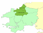
Eglwyswrw [ɛɡlʊɨˈsuːrʊ] is a village, community and parish in the former Cantref of Cemais, Pembrokeshire, Wales. The village lies between Newport and Cardigan at the junction of the A487 road and the B4332 at an altitude of 130 metres (430 ft).The village is in the heart of the Welsh-speaking area of Pembrokeshire; its history goes back at least to Norman times and there are 19 listed buildings in the community.
Excerpt from the Wikipedia article Eglwyswrw (License: CC BY-SA 3.0, Authors).Eglwyswrw
A487,
Geographical coordinates (GPS) Address Nearby Places Show on map
Geographical coordinates (GPS)
| Latitude | Longitude |
|---|---|
| N 52.014 ° | E -4.71 ° |
Address
The Young Farmers' Club
A487
SA41 3UJ , Eglwyswrw
Wales, United Kingdom
Open on Google Maps


