Thames Barrier
1984 establishments in EnglandBuildings and structures in the London Borough of NewhamBuildings and structures in the Royal Borough of GreenwichCharlton, LondonCoastal construction ... and 11 more
Dams completed in 1984Flood barriersFlood control in the United KingdomGeography of the River ThamesInfrastructure in LondonPages containing links to subscription-only contentPort of LondonSubscription required using viaTourist attractions in the London Borough of NewhamTourist attractions in the Royal Borough of GreenwichUse British English from December 2012

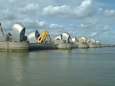
The Thames Barrier is a retractable barrier system built to protect the floodplain of most of Greater London from exceptionally high tides and storm surges moving up from the North Sea. It has been operational since 1982. When needed, it is closed (raised) during high tide; at low tide, it can be opened to restore the river's flow towards the sea. Built about 2 miles (3.2 kilometres) east of the Isle of Dogs, its northern bank is in Silvertown in the London Borough of Newham and its southern bank is in the New Charlton area of the Royal Borough of Greenwich.
Excerpt from the Wikipedia article Thames Barrier (License: CC BY-SA 3.0, Authors, Images).Thames Barrier
East Periphery, London Silvertown (London Borough of Newham)
Geographical coordinates (GPS) Address Nearby Places Show on map
Geographical coordinates (GPS)
| Latitude | Longitude |
|---|---|
| N 51.496944444444 ° | E 0.036666666666667 ° |
Address
East Periphery
E16 2GR London, Silvertown (London Borough of Newham)
England, United Kingdom
Open on Google Maps


