Batteriekopf
France geography stubsMountains of Haut-RhinMountains of the VosgesOne-thousanders of France

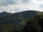
The Batteriekopf is a peak in the Vosges Mountains, reaching an altitude of 1,311 meters. This mountain borders the Route des Crêtes and is located immediately south of the Rothenbachkopf, spanning the municipalities of Wildenstein and Metzeral.
Excerpt from the Wikipedia article Batteriekopf (License: CC BY-SA 3.0, Authors, Images).Batteriekopf
Route des Crêtes, Thann-Guebwiller
Geographical coordinates (GPS) Address Website Nearby Places Show on map
Geographical coordinates (GPS)
| Latitude | Longitude |
|---|---|
| N 47.993888888889 ° | E 6.9805555555556 ° |
Address
Batteriekopf
Route des Crêtes
68700 Thann-Guebwiller
Grand Est, France
Open on Google Maps


