place

Savin Hill

1630 establishments in MassachusettsDorchester, BostonHistoric districts in Suffolk County, MassachusettsHistoric districts on the National Register of Historic Places in MassachusettsIrish-American neighborhoods
NRHP infobox with nocatNational Register of Historic Places in BostonNeighborhoods in BostonPopulated places established in 1630Streetcar suburbsUse mdy dates from January 2016
BostonMA SavinHillPark

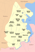
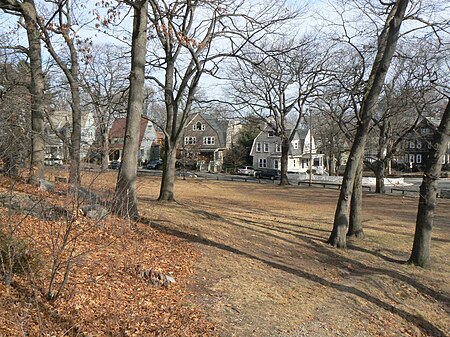
Savin Hill is a section of Dorchester, the largest neighborhood of Boston, Massachusetts, United States.Named after the geographic feature it covers and surrounds, Savin Hill is about one square mile in area, and has a population of about 15,000 people. Savin Hill Beach and Malibu Beach are nearby and are a resource for surrounding communities. Rail and bus routes give access to and from Savin Hill, especially the Savin Hill station. It is the home of the Savin Hill Yacht Club which was founded in 1875 as the Savin Hill Beach Association but later changed its name in 1888. The club is located off Morrissey Boulevard, a main artery in the area.

Excerpt from the Wikipedia article Savin Hill (License: CC BY-SA 3.0, Authors, Images).

Savin Hill
Savin Hill Avenue, Boston Dorchester

Geographical coordinates (GPS) Address Nearby Places
placeShow on map

Wikipedia: Savin HillContinue reading on Wikipedia

Geographical coordinates (GPS)

Latitude Longitude
N 42.309166666667 ° E -71.050277777778 °
placeShow on map

Address

Savin Hill Avenue 188
02125 Boston, Dorchester
Massachusetts, United States
mapOpen on Google Maps

BostonMA SavinHillPark
Share experience

Nearby Places

Dorchester, Boston
Dorchester, Boston

Dorchester is a Boston neighborhood comprising more than 6 square miles (16 km2) in the City of Boston, Massachusetts, United States. Originally, Dorchester was a separate town, founded by Puritans who emigrated in 1630 from Dorchester, Dorset, England, to the Massachusetts Bay Colony. This dissolved municipality, Boston's largest neighborhood by far, is often divided by city planners in order to create two planning areas roughly equivalent in size and population to other Boston neighborhoods. The neighborhood is named after the town of Dorchester in the English county of Dorset, from which Puritans emigrated on the ship Mary and John, among others.Founded in 1630, just a few months before the founding of the city of Boston, Dorchester now covers a geographic area approximately equivalent to nearby Cambridge. It was still a primarily rural town and had a population of 12,000 when it was annexed to Boston in 1870. Railroad and streetcar lines brought rapid growth, increasing the population to 150,000 by 1920. In the 2010 United States Census, the neighborhood's population was 92,115. The Dorchester neighborhood has a very diverse population, which includes a large concentration of African Americans, European Americans (particularly those of Irish, German, Italian, and Polish origin), Caribbean Americans, Latinos, and East and Southeast Asian Americans. Dorchester also has a significant LGBT population, with active political groups and the largest concentration of same-sex couples in Boston after the neighborhoods of South End and Jamaica Plain. Most of the people over the age of 25 have completed high school or obtained a GED.

The Mather School
The Mather School

The Mather School is the oldest public elementary school in North America. It is located in the Dorchester region of Boston, Massachusetts and was named after Richard Mather. Mather was an English-born American Congregational minister who emigrated to Boston and settled in Dorchester in 1635.On June 9 [O.S. May 20] 1639 The Dorchester Town Records reads the following: "It is ordered that the 20th of May 1639, that there shalbe a rent paid of 20ls yeerely foreur imposed upon Tomsons Iland to bee payd p euy p'son that hat p'prtie in the said Iland according to the p'portion that any such p'son shall fro tyme to tyem injoy and posesse there, and this towards the mayntenance of a schoole in Dorchestr this rent of 20ls yeerlyl to bee payd to such a schoolemaster as shall undertake to teach english latin and other tongues and also writing...." The first building was a one room schoolhouse and was located on what had been known as "Settlers' Street," near the corner of the present Pleasant and Cottage Streets. It served until 1694 when a contract was made with John Trescot to build a house twenty feet long and nineteen feet wide, with a ground floor, a chamber above, with a flight of stairs, and a chimney. The contract required the building to be boarded and clapboarded; to be filled up between the studs; to be fully covered with boards and shingles. The site of this building is supposed to be the hill near the meeting-house, on what is now known as Winter Street.The successor of this first school is the Mather School located at Meeting House Hill, the second building of that name. The previous building, erected in 1856, was located on the same site where the fire station is now. It was renamed the Edward Southworth School when the new Mather School was built in 1905, and has since been demolished.The Mather School, located on Parish Street just a few yards away from the original location, is operating for students of the Dorchester district spanning grades K–5. The school's mission is proficiency with support for all in reading, writing and math. Other classes offered are music, art, physical education, science, library and computers. Additional programs include tutoring, mentoring and nutrition education. The school has a culturally diverse student and staff body with seven specialty classes and a well equipped playground. The principal as of the 2021–22 school year is Hai Son.

JFK/UMass station
JFK/UMass station

JFK/UMass station is a Massachusetts Bay Transportation Authority (MBTA) intermodal transfer station, located adjacent to the Columbia Point area of Dorchester, Boston, Massachusetts. It is served by the rapid transit Red Line; the Greenbush Line, Kingston/Plymouth Line, and Middleborough/Lakeville Line of the MBTA Commuter Rail system, and three MBTA bus routes. The station is named for the John F. Kennedy Presidential Library and Museum and the University of Massachusetts Boston, both located nearby on Columbia Point. JFK/UMass station has four tracks and two island platforms for the Ashmont and Braintree branches of the Red Line, with one track and one side platform for Commuter Rail. A waiting room and fare lobby over the Red Line platforms is connected to Columbia Road, Sydney Street, and the busway on the east side of the station by footbridge. The station is fully accessible. North of the station, the complex Columbia Junction connects the two Red Line branches with the downtown tunnel and Cabot Yard lead tracks. The Old Colony Railroad first opened through the area in 1845, with Crescent Avenue station opened in 1868 and rebuilt in 1883. The Boston Elevated Railway began construction of Columbia station on the Dorchester Extension of the Cambridge–Dorchester Tunnel in 1925. Crescent Avenue station closed in July 1927; Columbia station opened on November 5, with an additional footbridge added in 1929. Columbia station was modernized in 1970, though without a platform for South Shore (Braintree Branch) service, which started in 1971. UMass Boston moved to Columbia Point in 1974, while the Kennedy Library opened in 1979; the station was renamed JFK/UMass in 1982. A 1987–88 renovation added a platform for the Braintree Branch. Commuter Rail service on the former Old Colony, last operated in 1959, resumed in 1997. However, the platform at JFK/UMass did not open until 2001.