Bullengraben

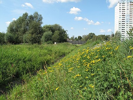
The Bullengraben is a moat in Berlin’s glacial valley, which has been in use since the 7th century. It is located in the Berlin district of Spandau and runs from the old village center of Staaken eastwards for about five kilometers to the Havel River, into which it flows north of the Spandau castle rampart. Used for centuries to improve the wetlands, since the 1960s it has been used as a drainage ditch to collect rainwater from the surrounding neighborhoods of Spandau. The development of the areas around the Bullengraben reflects part of Spandau's settlement history. Between 2004 and 2007, DB ProjektBau rehabilitated a ditch that had been canalized in the 1960s and 1970s but had later been neglected. This rehabilitation was conducted as part of a replacement measure. Parallel to the moat, the Deutsche Bahn subsidiary created the 200-meter-wide Bullengraben/Lindenufer green corridor with playgrounds and sports fields, recreational areas, bridges, footbridges, and a path that leads to Elsflether Weg. The Bullengrabenweg, one of Berlin's top 20 green paths, is open to pedestrians, cyclists, and skaters. The path is approximately four meters wide and has a smooth asphalt covering. The last section of the path includes the Burgwallgraben and a 100-metre-long promenade along the Havel. Additionally, biotopes located within the green corridor, such as the Stieglake and Wiesen basins, along with the ditches leading to them, such as the Egelpfuhlgraben, have undergone restoration. In 2008, Deutsche Bahn received the Gustav Meyer Prize for designing the entire park. This award is given every two years since 1995 to recognize excellent planning of public green spaces and parks. The prize bears the name of Johann Heinrich Gustav Meyer, Berlin's first municipal horticultural director.
Excerpt from the Wikipedia article Bullengraben (License: CC BY-SA 3.0, Authors, Images).Bullengraben
Hermann-Oxfort-Promenade, Berlin Spandau
Geographical coordinates (GPS) Address Nearby Places Show on map
Geographical coordinates (GPS)
| Latitude | Longitude |
|---|---|
| N 52.529166666667 ° | E 13.199722222222 ° |
Address
Hermann-Oxfort-Promenade
Hermann-Oxfort-Promenade
13581 Berlin, Spandau
Germany
Open on Google Maps


