Largo do Paiçandu
Central Zone of São PauloCommons link is defined as the pagenameSquares in BrazilSão PauloTourist attractions in São Paulo

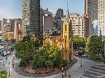
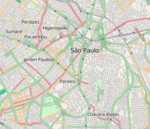
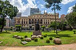
Largo do Paiçandu (in archaic spelling, Largo do Payssandu and Largo do Paissandu) is an area of the República district, in the central area of the city of São Paulo, Brazil. It was named in 1865 after the Siege of Paysandu. Currently, it It is located within a quadrilateral formed by São João, Conselheiro Crispiniano, Rio Branco and Dom José de Barros streets. At the end of the 19th century, it was an important circus zone in the city.
Excerpt from the Wikipedia article Largo do Paiçandu (License: CC BY-SA 3.0, Authors, Images).Largo do Paiçandu
Avenida São João, São Paulo República (República)
Geographical coordinates (GPS) Address Nearby Places Show on map
Geographical coordinates (GPS)
| Latitude | Longitude |
|---|---|
| N -23.543055555556 ° | E -46.638055555556 ° |
Address
Igreja de Nossa Senhora do Rosário dos Homens Pretos
Avenida São João
01036-000 São Paulo, República (República)
São Paulo, Brazil
Open on Google Maps


