Arbitration Rock
1769 establishments in New York18th century in BrooklynArbitration casesGeography of BrooklynGeography of Queens, New York ... and 2 more
History of Queens, New YorkInternal territorial disputes of the United States

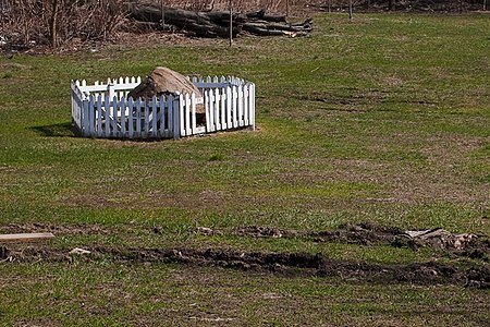
The Arbitration Rock was set in 1769 as the boundary marker between the two Long Island townships of Newtown and Bushwick. Since Newtown was in Queens County (now the New York City borough of Queens) and Bushwick in Kings County (now the borough of Brooklyn), this rock the size of a Volkswagen Beetle also served to mark the dividing line between these two colonial New York counties.
Excerpt from the Wikipedia article Arbitration Rock (License: CC BY-SA 3.0, Authors, Images).Arbitration Rock
Flushing Avenue, New York Queens
Geographical coordinates (GPS) Address Website External links Nearby Places Show on map
Geographical coordinates (GPS)
| Latitude | Longitude |
|---|---|
| N 40.710694444444 ° | E -73.919555555556 ° |
Address
Arbitration Rock
Flushing Avenue 18-20
11237 New York, Queens
New York, United States
Open on Google Maps


