Lake Rotomakariri

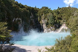
Lake Rotomakariri (From Māori: roto, meaning lake, and makariri, meaning cold) was a lake which formerly existed in the basin that is now occupied by Lake Rotomahana, in the Bay of Plenty region of New Zealand's North Island. The lake's name was in contrast to the nearby Lake Rotomahana, which prior to the 1886 eruption of Mount Tarawera, was a shallower warm water lake. Prior to this eruption, Lake Rotomakariri sat in a shallow basin surrounded by marshes, draining into Lake Tarawera by Awapurohe Creek and Rotomahana's outflow of Kaiwaka Stream. The eruption of Mount Tarawera initially destroyed Lake Rotomakariri and its lakeside village with the loss of 19 lives, though water entering the new crater gradually refilled Lake Rotomakariri after volcanic activity subsided. As water accumulated over the decade after the eruption, Lake Rotomakariri was absorbed by the larger Lake Rotomahana, which eventually rose to about 36–48 m (118–157 ft) above its pre-eruption level due to the previous outflow of the basin being blocked by ashfall.
Excerpt from the Wikipedia article Lake Rotomakariri (License: CC BY-SA 3.0, Authors, Images).Lake Rotomakariri
Geographical coordinates (GPS) Address Nearby Places Show on map
 Continue reading on Wikipedia
 Geographical coordinates (GPS)
| Latitude | Longitude |
|---|---|
| N -38.26 ° | E 176.445 ° |
Address
Rotorua Lakes District (Rotorua District)
Bay of Plenty, New Zealand
Open on Google Maps