Te Wairoa, New Zealand
1840s architecture in New Zealand1886 eruption of Mount TaraweraArchaeological museumsArchaeological sites in New ZealandBuildings and structures in the Bay of Plenty Region ... and 9 more
Former populated places in New ZealandGhost towns in New ZealandHistory museums in New ZealandMuseums in the Bay of Plenty RegionNatural disaster ghost townsOkataina Volcanic CentreTaupō Volcanic ZoneTourist attractions in RotoruaWaterfalls of New Zealand

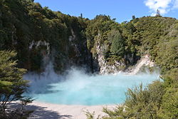
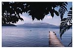
Te Wairoa was a village close to the shore of Lake Tarawera near Rotorua, New Zealand. The village was buried by volcanic ash in the 1886 eruption of Mount Tarawera. It was later excavated and is now open as a tourist destination, the Buried Village. The nearby Wairere Falls are also a tourist destination. The Buried Village is open to the public and shows the excavated ruins of the village, recovered relics on display in a museum and the history of the eruption. It is located 14 kilometres (8.7 mi) south-east of Rotorua on Tarawera Road. The New Zealand Ministry for Culture and Heritage gives a translation of 'the long stream' for Te Wairoa.
Excerpt from the Wikipedia article Te Wairoa, New Zealand (License: CC BY-SA 3.0, Authors, Images).Te Wairoa, New Zealand
Tarawera Road,
Geographical coordinates (GPS) Address Phone number Website External links Nearby Places Show on map
 Continue reading on Wikipedia
 Geographical coordinates (GPS)
| Latitude | Longitude |
|---|---|
| N -38.212598 ° | E 176.364575 ° |
Address
Buried Village
Tarawera Road 1180
Bay of Plenty, New Zealand
Open on Google Maps
Phone number
Website
buriedvillage.co.nz
External links