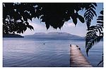
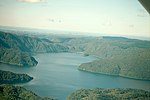
Rotoiti Caldera
The Rotoiti Caldera is a postulated, mainly infilled sub caldera of the Ōkataina Caldera based upon gravitational and magnetic evidence. It erupted 100 cubic kilometres (24 cu mi) of magma that is used in the recent stratigraphy of much of the northern North Island. It was formed in the larger paired eruption with the lesser Earthquake Flat vents linked by tectonic interaction across the length of the Ōkataina Caldera. The series of eruptions was about 50,000 years ago, with the resulting widespread Rotoiti ignimbrite and several layers of Rotoiti/Rotoehu tephra/brecca/ash giving challenges in consistent dating.: 188–90 It was subsequently infilled by later eruptive activity to a depth of over 2 km (1.2 mi). The paired eruptions may have erupted about 240 cubic kilometres (58 cu mi) of tephra.
Excerpt from the Wikipedia article Rotoiti Caldera (License: CC BY-SA 3.0, Authors).Rotoiti Caldera
Geographical coordinates (GPS) Address Nearby Places Show on map
 Continue reading on Wikipedia
 Geographical coordinates (GPS)
| Latitude | Longitude |
|---|---|
| N -38.166666666667 ° | E 176.5 ° |
Address
Rotorua Lakes District (Rotorua District)
Bay of Plenty, New Zealand
Open on Google Maps