Sir John McDougall Gardens

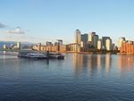
Sir John McDougall Gardens is a grassed and wooded area along the River Thames on the Isle of Dogs in London, England. It houses a playground, an outdoor gym and a Thames-side path. It covers just over 6 acres (2.4 ha), between the River Thames and Westferry Road.The park is named after Sir John McDougall, a local member of the London County Council (LCC) in the 1900s. He was a flour miller and owned a nearby mill, the Wheatsheaf Mill, demolished in 1980. Sir John McDougall Gardens was opened in 1968, on a site left in ruins by the bombing of Docklands in World War II. Local children were involved in the original planting of trees. A footbridge across Westferry Road was completed in 1969 to link it directly to the large Barkantine Estate of social housing.The park was re-modelled in the 1980s by the London Docklands Development Corporation when the ground level was bought up to the top of the river wall to allow a view of the River Thames.
Excerpt from the Wikipedia article Sir John McDougall Gardens (License: CC BY-SA 3.0, Authors, Images).Sir John McDougall Gardens
Arnhem Place, London Isle of Dogs
Geographical coordinates (GPS) Address Nearby Places Show on map
Geographical coordinates (GPS)
| Latitude | Longitude |
|---|---|
| N 51.496944444444 ° | E -0.026666666666667 ° |
Address
Arnhem Place
E14 8PD London, Isle of Dogs
England, United Kingdom
Open on Google Maps


