place

Mount Jefferson (New Hampshire)

Mountains of Coös County, New HampshireMountains of New HampshireNew Hampshire geography stubsWhite Mountains (New Hampshire)
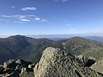
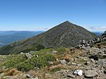
Mt. Jefferson from Mt. Washington

Mount Jefferson is located in Coos County, New Hampshire, and is the third highest mountain in the state. The mountain is named after Thomas Jefferson, the third president of the United States, and is part of the Presidential Range of the White Mountains. Mount Jefferson is flanked by Mount Adams (to the northeast) and Mount Clay (to the south). The mountain has several interesting features, making it a popular hike. Two distinct ridges lead to its summit: Ridge of the Caps and Castle Ridge. The mountain is surrounded by the three dramatic glacial cirques of Jefferson Ravine, Castle Ravine, and the Great Gulf. Finally, Monticello Lawn is a large expanse of alpine sedge and rush near the otherwise talus-covered summit cone. When viewed from the Mount Washington Auto Road, Jefferson features an arrow-shaped bald patch pointing to its summit. Mount Jefferson has a direct ascent along the Caps Ridge Trail, whose base, Jefferson Notch, is the highest point of any public road in New Hampshire at 3,009 feet (917 m). This route, gaining only 2,700 feet (823 m) vertically to the summit, results in it having the least distance of ascent of any Presidential mountain (about 2.5 miles). However, climbing over the "caps" involves some exposed scrambling and can be steep and challenging at times.

Excerpt from the Wikipedia article Mount Jefferson (New Hampshire) (License: CC BY-SA 3.0, Authors, Images).

Mount Jefferson (New Hampshire)
Caps Ridge Trail,

Geographical coordinates (GPS) Address Nearby Places
placeShow on map

Wikipedia: Mount Jefferson (New Hampshire)Continue reading on Wikipedia

Geographical coordinates (GPS)

Latitude Longitude
N 44.3042 ° E -71.31685 °
placeShow on map

Address

Caps Ridge Trail

Caps Ridge Trail
03589 (Thompson and Meserve's Purchase)
New Hampshire, United States
mapOpen on Google Maps

Mt. Jefferson from Mt. Washington
Share experience

Nearby Places

Mount Adams (New Hampshire)

Mount Adams, elevation 5,793 feet (1,766 m) above sea level, is a mountain in New Hampshire, the second highest peak in the Northeast United States after its nearby neighbor, Mount Washington. Located in the northern Presidential Range, Mount Adams was named after John Adams, the second President of the United States. It was given this name on July 31, 1820. To the northeast is Mount Madison and to the southwest is Mount Jefferson. From the summit, Mount Washington can be seen directly to the south. There are two major subsidiary peaks of Mount Adams: Mount Sam Adams and Mount Quincy Adams, named after John Adams' cousin, Revolutionary leader Samuel Adams, and son, President John Quincy Adams, respectively, and two minor sub-peaks, Abigail Adams (named for John Adams' wife Abigail) and Adams 5. The northern side of the mountain ridge is located in Low and Burbank's Grant, and the end of Durand Ridge, and King Ravine, on the north side of Mount Adams are in the town of Randolph (formerly Durand). The entire south side of the mountain ridge is in Thompson and Meserve's Purchase. The Appalachian Trail traverses the col between Mount Adams and Mount Sam Adams on the Gulfside Trail. The Randolph Mountain Club (RMC) maintains the trails and several huts and shelters high on Mount Adams' north side, including "The Perch", "Crag Camp", "The Log Cabin", and "Gray Knob". A large network of hiking and climbing paths lead south to the huts and ridges from several parking areas located on U.S. Highway 2. The Aetherius Society claims that Mount Adams is one of 19 "holy mountains" around the world.