place

Liston Range Front Light

1906 establishments in DelawareDelaware building and structure stubsLighthouses completed in 1906Lighthouses in New Castle County, DelawareLighthouses on the National Register of Historic Places in Delaware
National Register of Historic Places in New Castle County, DelawareUnited States lighthouse stubs
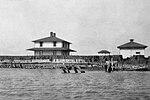
Liston Front Range Light, ca 1913, (New Castle County, Delaware)

Liston Range Front Lighthouse is a lighthouse in Delaware, United States, on the Delaware River. It is a range light, paired with the Liston Range Rear Light, to create the Liston Range.

Excerpt from the Wikipedia article Liston Range Front Light (License: CC BY-SA 3.0, Authors, Images).

Liston Range Front Light
South New Road,

Geographical coordinates (GPS) Address External links Nearby Places
placeShow on map

Wikipedia: Liston Range Front LightContinue reading on Wikipedia

Geographical coordinates (GPS)

Latitude Longitude
N 39.482583333333 ° E -75.591666666667 °
placeShow on map

Address

Liston Range Front Light

South New Road
19709
Delaware, United States
mapOpen on Google Maps

linkWikiData (Q6646549)
linkOpenStreetMap (376610441)

Liston Front Range Light, ca 1913, (New Castle County, Delaware)
Share experience

Nearby Places

Appoquinimink River
Appoquinimink River

The Appoquinimink River is a river flowing to Delaware Bay in northern Delaware in the United States. The river is 15.3 miles (24.6 km) long and drains an area of 47 square miles (120 km2) on the Atlantic Coastal Plain. The Appoquinimink flows for its entire length in southern New Castle County. It rises approximately 2 miles (3 km) west of Townsend and flows generally eastwardly, south of Middletown and past Odessa, to its mouth at the northern end of Delaware Bay, approximately 3 miles (5 km) east of Odessa. In its upper course the river passes through two man-made lakes, Wiggins Mill Pond and Noxontown Lake; the river is tidal to the dam at Noxontown Lake, and salinity from Delaware Bay typically affects the lowermost 5 miles (8 km) of the river. The lower 7 miles (11 km) of the river are considered to be navigable by the U.S. Army Corps of Engineers.It collects three named tributaries along its course: From the north, Deep Creek, 4.2 miles (6.8 km) long (also known historically as the "North Appoquinimink River"); and Drawyers Creek, 8.2 miles (13.2 km) long; and from the south, Hangmans Run.According to 2002 data from the United States Environmental Protection Agency, 54.9% of the Appoquinimink River watershed is occupied by agricultural uses (predominantly soybeans, corn, and wheat); 15.1% is residential; 9.9% is wetland; and 8.8% is forested.In 2004, a non-profit group, The Appoquinimink River Association, was founded with a mission to protect the water and natural resources in the region surrounding the Appoquinimink River.