place

University of New Orleans

1956 establishments in LouisianaPublic universities and colleges in LouisianaUniversities and colleges accredited by the Southern Association of Colleges and SchoolsUniversities and colleges established in 1956University of New Orleans
Use mdy dates from September 2019
University of New Orleans

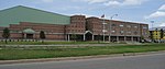
The University of New Orleans (UNO) is a public research university in New Orleans, Louisiana. First opened in 1958 as Louisiana State University in New Orleans, it is the largest public university and one of two doctoral research universities in the Greater New Orleans region. UNO is a member of the University of Louisiana System and is classified among "R2: Doctoral Universities – High research activity". The university consists of 8 schools and colleges offering 40 bachelor's, 45 master's and 17 doctoral degrees. Among its academic offerings are the only civil, mechanical and electrical engineering programs in New Orleans, the only graduate hospitality and tourism program and PAB-accredited urban planning program in the state of Louisiana, and one of the only schools of naval architecture and engineering in the United States. UNO's 195-acre main campus is located on the shores of Lake Pontchartrain in Gentilly, New Orleans. The university's East Campus houses athletic facilities including Maestri Field and the UNO Lakefront Arena. UNO also owns and operates The Beach, a research and technology park adjacent to its main campus. The university's athletic teams are the Privateers. A total of 14 Privateer teams compete in the NCAA Division I Southland Conference.

Excerpt from the Wikipedia article University of New Orleans (License: CC BY-SA 3.0, Authors, Images).

University of New Orleans
Frankfort Street, New Orleans Spanish Fort

Geographical coordinates (GPS) Address External links Nearby Places
placeShow on map

Wikipedia: University of New OrleansContinue reading on Wikipedia

Geographical coordinates (GPS)

Latitude Longitude
N 30.0275 ° E -90.0671 °
placeShow on map

Address

University of New Orleans

Frankfort Street
70122 New Orleans, Spanish Fort
Louisiana, United States
mapOpen on Google Maps

linkWikiData (Q1474157)
linkOpenStreetMap (38499519)

University of New Orleans
Share experience

Nearby Places

Benjamin Franklin High School (New Orleans)

Benjamin Franklin High School is a charter high school and a magnet high school in New Orleans, Louisiana. Commonly nicknamed "Franklin" or "Ben Franklin", the school was founded in 1957 as a school for gifted children. Ben Franklin is consistently named the No.1 school in the state of Louisiana and has been ranked by U.S. News & World Report as No. 15 charter school in the nation. In 1990, it moved to its current location on the campus of the University of New Orleans (UNO) in the Lake Terrace/Lake Oaks neighborhood of Orleans Parish, near Lake Pontchartrain. The school was damaged by several feet of flood water due to Hurricane Katrina in the fall of 2005, and efforts to reopen the school were covered by nationwide news agencies. The school is part of the Orleans Parish School Board (OPSB), yet it operates as a charter school and is not administered directly by the agency. Ben Franklin has a selective admissions process, and according to CBS News is a "magnet for the city's smart and motivated students." Andrew Vanacore, of The Times Picayune, wrote in 2013 that Franklin was "top-notch". It has been named a Blue Ribbon School five times by the U.S. Department of Education, and was ranked 16 on the 2009 "America's Best High Schools" list by U.S. News & World Report. The class of 2008 produced 17 National Achievement Semifinalists, the most of any school in the United States. In 2021, U.S. News & World Report ranked the school as the best public high school in Louisiana and the 64th best in the United States.Ben Franklin is a member of the Louisiana High School Athletic Association and offers a variety of sports programs. Extracurricular activities are also offered in the form of performing arts, school publications, and clubs. Notable alumni of the school include Wynton Marsalis, a Pulitzer Prize winning trumpeter, actor Wendell Pierce, and Cedric Richmond, former congressman and Senior Advisor to U.S. President Joe Biden.

Pontchartrain Beach
Pontchartrain Beach

Pontchartrain Beach was an amusement park located in New Orleans, Louisiana, on the south shore of Lake Pontchartrain. It was founded by Harry J. Batt Sr. (grandfather of American actor Bryan Batt) and later managed and owned by his sons, Harry J. Batt Jr. and John A. Batt. It opened on Saturday, June 30, 1928, across Bayou St. John from an existing amusement resort at Old Spanish Fort. Pontchartrain Beach's original location is the present-day lakefront neighborhood of Lake Terrace. In the early 1930s, subsequent to the construction of a seawall extending from West End to the Industrial Canal which created a new shoreline for Lake Pontchartrain, Pontchartrain Beach was moved to a new location at the lake end of Elysian Fields Avenue, a location formerly offshore of Milneburg. Pontchartrain Beach included a beach with a large art deco style bathhouse and swimming pools, amusement rides (including a wooden roller coaster called the Zephyr), and concession stands. The park featured live music concerts, including many local musicians and touring national acts such as Elvis Presley. Other rides and amusements included the Zephyr Junior, Smoky Mary, the Wild Maus, Musik Express, Log Ride, the Ragin' Cajun (a modern, looping steel coaster), the Bug, Paratrooper, Scrambler, Calypso, the "airplanes", Haunted House, Ghost Train, bumper cars, carousel, Ferris wheel, the Monster, Trabant, Sky Ride, Hard Rock, Galaxy, Laff in the Dark, Magic Rainbow, Red Baron, and Kiddieland. As with other amusement or theme parks, over time certain older rides were changed out for new ones. In addition to rides, there were also the summertime shows which changed every few years (Skipper & Dolly dolphin show, Great American High Dive Show, Merlin's Magic Rainbow Show). For a few years there was also a fairly large petting zoo with many farm animals and a huge red barn house. A miniature golf course was added, when this pastime became popular. Just outside the entrance gates was the Bali Hai Tiki-style restaurant. Another popular restaurant was the Ship Ahoy, which featured hamburgers and seafood. Pontchartrain Beach was sold on September 23, 1983. The main reason it closed down was due to declining attendance.In 1943, Corporal Douglas O'Brien, a World War II serviceman from Springfield, Massachusetts, fell 75 feet (23 m) to his death from the top of the Zephyr roller coaster. He was 32 years old.

Bayou St. John
Bayou St. John

Bayou St. John (French: Bayou Saint-Jean) is a bayou within the city of New Orleans, Louisiana. The Bayou as a natural feature drained the swampy land of a good portion of what was to become New Orleans, into Lake Pontchartrain. In its natural state, it extended much farther than today; 18th- and early 19th-century maps show it had tributaries or branches (at least seasonally) reaching into what are now the Broadmoor neighborhood, the New Orleans Central Business District just back from St. Charles Avenue above Lee Circle, the Carrollton neighborhood, the Treme neighborhood, and a branch connecting to Bayou Gentilly. The portion still in existence today was navigable by canoes and similar small vessels, used by Native Americans since pre-Columbian times. The natives knew the waterway as Bayouk Choupic. There was a portage between the Bayou and the Mississippi River due to the difference in water level between the bayou and the level of the sea, which attracted early French explorers, traders, and trappers, some of whom established a small community there by the late 17th century. In 1701 a small fort was established by the French beside the Lake Pontchartrain end of the Bayou to protect this important route; Fort St. Jean would be known to future generations of New Orleanians as "Old Spanish Fort". The Bayou and portage were key factors in the selection of the site where the city was founded in 1718, at the River end of the portage route. The portage trail along the bayou became the "Grand Route St. John" which eventually was replaced by the wide, straight Esplanade Avenue. After the destructive hurricanes of 1778 and 1779, the charitable Bayou plantation owner, Don Andres Almonester, rebuilt the Charity Hospital. Earlier Almonester had founded a leper's hospital near the portage road prior to the construction of the important Carondelet waterway. After the Louisiana Purchase in 1803, the Carondelet Canal was dug to connect the back of the city (when it was limited to the strip of land along the Mississippi River) with the Bayou, and the Bayou was dredged to accommodate larger vessels. In the 19th century, an area along Bayou St. John was reputedly the location of many voodoo rituals by Marie Laveau. The Magnolia Bridge over the Bayou continues to serve as a site for such rituals every St. John's Eve. During the first half of the 20th century, commercial use of the Bayou declined and the Carondelet Canal was filled in. Some New Orleanians began living in houseboats on the Bayou. Complaints from residents of nearby neighborhoods and sanitation concerns led to this practice being outlawed in the 1930s. A Works Progress Administration project cleaned up and beautified the area. A lock was installed near the Lake Pontchartrain end. In the summer of 1955, the New Orleans Sewerage and Water Board temporarily drained the Bayou, to clean out debris and material that was causing foul odors. Since then, the Bayou has been a picturesque body of water with small earthen levees on either side, forming a narrow park space in the city. From the mid-20th century on, the banks of the Bayou across from City Park became a favorite destination for young couples seeking privacy. The banks of Bayou St. John are an important meeting place for the downtown Mardi Gras Indian tribes for their "Super Sunday" parade after Carnival. Officially opened in 2015, the Lafitte Greenway now runs along the corridor previously occupied by the Carondelet Canal, with a prominent roundabout at the foot of the Bayou. In conjunction with the Lafitte Greenway, the Bayou has been recognized as part of the EPA's Urban Waters Partnership.