place

Holy Innocents Church, Lamarsh

Braintree DistrictChurch of England church buildings in EssexChurches in the Diocese of ChelmsfordGrade I listed churches in EssexRound-tower churches
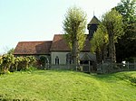
Holy Innocents church, Lamarsh, Essex geograph.org.uk 168354

Holy Innocents Church is an Anglican church in the village of Lamarsh, in Essex, England. The building has a round tower and dates from the 12th century. It is a Grade I listed building.

Excerpt from the Wikipedia article Holy Innocents Church, Lamarsh (License: CC BY-SA 3.0, Authors, Images).

Holy Innocents Church, Lamarsh
Henny Road, Essex

Geographical coordinates (GPS) Address Nearby Places
placeShow on map

Wikipedia: Holy Innocents Church, LamarshContinue reading on Wikipedia

Geographical coordinates (GPS)

Latitude Longitude
N 51.990777777778 ° E 0.75097222222222 °
placeShow on map

Address

Henny Road
CO8 5EU Essex
England, United Kingdom
mapOpen on Google Maps

Holy Innocents church, Lamarsh, Essex geograph.org.uk 168354
Share experience

Nearby Places

Henny Street
Henny Street

Henny Street is a hamlet in the civil parish of Great Henny and the Braintree district of Essex, England. The hamlet is on Henny Road at the east of the parish and adjacent to the west bank of the River Stour. Henny Street is a linear hamlet south from, but incorporating, the junction of the road to Middleton, the adjacent parish to the north. The hamlet holds three Grade II listed buildings. Henny Cottage dates to the 14th century, was formerly a hall house and is plastered, timber framed and thatched. The timber framed, plastered and gabled Street Farmhouse, the focus of Street Farm, dates to the 15th century with later additions and alterations. Mill House, on the Stour side of the hamlet is early 19th century, plastered over timber framing. Between Mill house and the Stour is the redeveloped site of the former Henny Mill which was a water powered corn mill, later using steam, served by the Stour. To the north from Street Farm is The Swan public house and restaurant, whose facilities include ground across Henny Road to the Stour. Within the property at the edge of the Stour are the remains of a Second World War Type 22 pillbox. The Swan and its victuallers are listed in trade directories from at least 1848 to at least 1933. Up to 1914 the victualler was also blacksmith, however, in 1863 he was also a farmer, and in 1894, a brewer. The miller at Henny Mill was the same person from at least 1863 to later than 1902. By 1914, the miller's executors were in control, the mill listed as using steam as well as water power, and from 1902 to at least 1914, the miller was also a baker. A miller was still trading in 1933. Farmers at Street Farm were listed from 1848 to 1933, the farmer in 1902 also employing a bailiff.

Bures Hamlet

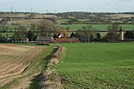
Bures Hamlet is a civil parish in the Braintree district of Essex, England. At the 2011 census, it had a population of 749.The parish covers the western part of the village of Bures, the eastern part being in the Bures St. Mary parish in Suffolk. It also includes Daw's Cross. Bures railway station is in the parish. The civil parish of Bures Hamlet rises from the west bank of the River Stour, in the county of Essex – the ancient Kingdom of the East Saxons, although it remains in the ecclesiastical parish of Bures St. Mary, Suffolk – land of the South Folk of the East Angles. This anomaly was first recorded in the footnotes to the Domesday Book of 1086 which correct the allocation of Bures lands between the counties. The most populated part of the parish is the Hamlet itself, which flanks the river between the 20m and 25m (65’ and 81’) contour lines. Named when no more than a few scattered cottages, the Hamlet now rivals its parent Parish in size, with a population of some 765 people. The rest of the parish of Bures Hamlet is undulating agricultural land with scattered patches of woodland, some being remnants of the ancient forest and later deer parks. Much of the parish lies between the valleys of the River Stour and Cambridge Brook. There are no other major settlements, but a few clusters of cottages by ancient greens and crossroads, and some isolated farms. The highest point in the parish is on the southwest corner of the parish boundary at 73m (237’). There are wide views into the Stour Valley from many parts of the parish. An extensive network of public rights-of-Way provides off-road access to many parts of the parish. In addition, minor lanes that are relatively traffic-free intersect much of the parish, and while care must be taken in case vehicles are using the often winding and high-banked lanes, these can combine well with paths and bridleways to provide round and linear routes.