Derbyshire

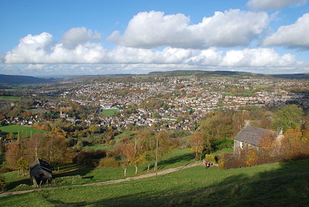
Derbyshire ( DAR-bee-sheer, -shər, -ih) is a ceremonial and non-metropolitan county in the East Midlands, England. The county is the westernmost in the East Midlands. It covers much of the Peak District National Park, the southern end of the Pennine range of hills and part of the National Forest. It is bordered by Greater Manchester to the north-west, West Yorkshire to the north, South Yorkshire to the north-east, Nottinghamshire to the east, Leicestershire to the south-east, Staffordshire to the west and south-west, and Cheshire to the west. The county's largest settlement and only city, Derby, is now administered as a unitary authority. The rest of Derbyshire remains in the Derbyshire County Council local authority area. Derbyshire was historically larger, once extending to cover some southern suburbs of Sheffield such as Mosborough, Owlthorpe, Jordanthorpe, Totley, Dore and Abbeydale.Kinder Scout, at 636 m (2,087 ft), is the highest point and Trent Meadows, where the River Trent leaves Derbyshire, the lowest at 27 m (89 ft).: 1 The north–south River Derwent is the longest river at 66 mi (106 km). In 2003, the Ordnance Survey named Church Flatts Farm at Coton in the Elms, near Swadlincote, as Britain's furthest point from the sea.
Excerpt from the Wikipedia article Derbyshire (License: CC BY-SA 3.0, Authors, Images).Derbyshire
Dale Road North, Derbyshire Dales Northwood and Tinkersley CP
Geographical coordinates (GPS) Address Nearby Places Show on map
Geographical coordinates (GPS)
| Latitude | Longitude |
|---|---|
| N 53.18 ° | E -1.61 ° |
Address
Dale Road North
Dale Road North
DE4 2LF Derbyshire Dales, Northwood and Tinkersley CP
England, United Kingdom
Open on Google Maps


