place

Owamni

2021 establishments in MinnesotaCulture of MinneapolisJames Beard Foundation Award for Best New RestaurantNative American restaurants in the United StatesRestaurants established in 2021
Restaurants in MinnesotaUse mdy dates from September 2022
Owamni Tisch crop
Owamni Tisch crop

Owamni by the Sioux Chef, or simply Owamni, is a Native American restaurant in downtown Minneapolis, Minnesota, overlooking the Mississippi River. Owamni's majority Native American staff serves a menu made from indigenous ingredients such as game meats, corn, and wild plants. The restaurant does not serve ingredients that were introduced to the region by Europeans, including butter, dairy, sugar, wheat, chicken, beef, and pork.

Excerpt from the Wikipedia article Owamni (License: CC BY-SA 3.0, Authors, Images).

Owamni
South 1st Street, Minneapolis

Geographical coordinates (GPS) Address Website Nearby Places
placeShow on map

Wikipedia: OwamniContinue reading on Wikipedia

Geographical coordinates (GPS)

Latitude Longitude
N 44.981111111111 ° E -93.260277777778 °
placeShow on map

Address

Owamni By The Sioux Chef

South 1st Street 420
55401 Minneapolis
Minnesota, United States
mapOpen on Google Maps

Website
owamni.com

linkVisit website

Owamni Tisch crop
Owamni Tisch crop
Share experience

Nearby Places

Saint Anthony Falls
Saint Anthony Falls

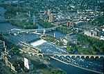
Saint Anthony Falls, or the Falls of Saint Anthony (Dakota: Owámniyomni, lit. 'Three Whirlpools') located at the northeastern edge of downtown Minneapolis, Minnesota, is the only natural major waterfall on the Mississippi River. Throughout the mid-to-late 1800’s, various dams were built atop the east and west faces of the falls to support the milling industry that spurred the growth of the city of Minneapolis. In 1880, the central face of the falls was reinforced with a sloping timber apron to stop the upstream erosion of the falls. In the 1950s, the apron was rebuilt with concrete, which makes up the most visible portion of the falls today. A series of locks were constructed in the 1950s and 1960s to extend navigation to points upstream.The falls were renamed from their Dakota title in 1680 by Father Louis Hennepin after his patron saint, St. Anthony of Padua. The towns of St. Anthony and Minneapolis, which had developed on the east and west sides of the falls, respectively, merged in 1872 to fully use the power of the falls for milling operations. From 1880 to about 1930, Minneapolis was known as the "Flour Milling Capital of the World". Today, the falls are defined by the spillway, the upper dam and the locks, located just downstream of the 3rd Avenue Bridge, and the Lower Lock and Dam, just upstream of the I-35W Saint Anthony Falls Bridge. These locks were built as part of the Upper Mississippi River 9-Foot Navigation Project. The area around the falls is designated the St. Anthony Falls Historic District and features a 1.8-mile (2.9 km) self-guided walking trail with signs explaining the area's past.

Mill Ruins Park
Mill Ruins Park

Mill Ruins Park is a park in downtown Minneapolis, Minnesota, United States, standing on the west side of Saint Anthony Falls on the Mississippi River and running from 3rd Ave. S. to about 9th Ave. S. The park interprets the history of flour milling in Minneapolis and shows the ruins of several flour mills that were abandoned. The park is the result of an archaeological study of the Saint Anthony Falls Historic District. The district was listed on the National Register of Historic Places in 1971. In 1983, a project was being considered to extend West River Parkway along the west side of the Mississippi River in downtown Minneapolis. Scott Anfinson, then the municipal county highway archaeologist for the Minnesota Historical Society, developed a plan to assess archaeological sites along the riverfront. A number of test excavations along the route revealed a wide variety of sites containing items of interest. In the Bassett's Creek area, for example, the foundations of two sawmills and the remains of a railroad roundhouse were found, while near Hennepin Avenue, the investigation found the footings of the Great Northern Railway Union Depot and the tower bases of the first and second Hennepin Avenue Bridges. In the milling district, archaeologists found clues suggesting that there were still extensive remains of the foundations of the mills and waterpower system.The first round of archaeological surveys in the 1980s was intended to save the ruins from destruction as a result of road construction projects. Later, in the 1990s, the focus shifted from environmental impact assessment to exposing ruins for their interpretive value. As the ruins were made visible to the public, the goal was to create assets for education, tourism, and commercial development. The excavations for Mill Ruins Park began in 1998 and continued through 2001. The process also involved stabilizing the remains of the Washburn "A" Mill, which had burned in 1991. The Washburn "A" Mill became part of the Mill City Museum.Along with the remains of about 20 flour mills and other industrial buildings, the park also contains two stone piers and several iron girder piers that held a trestle for the Minneapolis Eastern Railroad. The tailraces from the waterpower canal are also clearly visible, and the water flow has been restored through the canal. Signs posted along the walkways interpret the ruins and the history of the area.

Eastman tunnel
Eastman tunnel

The Eastman tunnel, also called the Hennepin Island tunnel, was a 2,000-foot-long (610 m) underground passage in Saint Anthony, Minnesota, (now Minneapolis) dug beneath the Mississippi River riverbed between 1868 and 1869 to create a tailrace so water-powered business could be located upstream of Saint Anthony Falls on Nicollet Island. The tunnel ran downstream from Nicollet Island, beneath Hennepin Island, and exited below Saint Anthony Falls. During construction of the tunnel, on October 5, 1869, the river broke through the thin layer of limestone separating the river's bed from the tunnel. The rushing river scoured the tunnel, caving in parts of Hennepin Island and causing the earth supporting Saint Anthony Falls to collapse upstream. There was serious concern that the riverbed would crumble and reduce Saint Anthony Falls to a long set of rapids. Within a few weeks, dams were built to divert the river and stop Saint Anthony Falls from being washed away. The fix was temporary as the 1870 spring floods damaged some of the new dams and swept away more of Hennepin Island. The final fix for the tunnel disaster was a concrete dike constructed by the United States Army Corps of Engineers. The Corps also built a protective sloping wood timber apron to create an artificial falls which remain the only major waterfall on the Mississippi River. The Eastman tunnel is a contributing resource to the St. Anthony Falls Historic District. The District is on the National Register of Historic Places The site of the tunnel is about a mile upstream from site of the I-35W Mississippi River bridge that collapsed in 2007.