place

Greensborough railway station

Premium Melbourne railway stationsRailway stations in Australia opened in 1902Railway stations in the City of BanyuleUse Australian English from February 2015
Greensborough Northeast

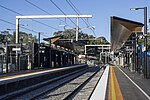
Greensborough railway station is located on the Hurstbridge line in Victoria, Australia. It serves the north-eastern Melbourne suburb of Greensborough, and it opened on 5 June 1902.Because of the curvature of the line, north-bound (Hurstbridge) services head south-east upon departing the station and, likewise, south-bound (Flinders Street) services head north-west. A number of peak-hour services to and from Flinders Street terminate at Greensborough.

Excerpt from the Wikipedia article Greensborough railway station (License: CC BY-SA 3.0, Authors, Images).

Greensborough railway station
Para Road, Melbourne Greensborough

Geographical coordinates (GPS) Address Nearby Places
placeShow on map

Wikipedia: Greensborough railway stationContinue reading on Wikipedia

Geographical coordinates (GPS)

Latitude Longitude
N -37.704 ° E 145.1081 °
placeShow on map

Address

Platforms 1 & 2

Para Road
3088 Melbourne, Greensborough
Victoria, Australia
mapOpen on Google Maps

Greensborough Northeast
Share experience

Nearby Places

Willinda Park

Willinda Park, Greensborough is located at the end of Nell Street, Greensborough and is maintained by the City of Banyule and the Willinda Park Committee of Management. Willinda Park has a polyurethane athletic track and is the home of Diamond Valley Little Athletics Centre, Diamond Valley Athletic Club and Ivanhoe Harriers What is now Willinda Park was once market gardens owned by William and Beatrice Linda Holmes. Hence how the name Willinda was derived. In 1963 and following William's death the Melbourne and Metropolitan Board of Works compulsorily acquired the majority of the Holmes property; a little over 9 acres (36,000 m2) for drainage and sewerage purposes for the sum of 6927 pounds. As was common practice in these times the Melbourne and Metropolitan Board of Works made such land available to local councils as reserves, often for recreation purposes. In April 1967, Linda Holmes voluntarily transferred a further small triangular section of land approximately 25 feet (7.6 m) x 80 feet (24 m) x 89 feet (27 m) in size to the Shire of Diamond Valley for $650 to assist in accessing the larger portion of land. This smaller section of land is still easily identifiable today as it forms part of the entrance to the park giving the property on the left (21 Talbot Street) with the red brick wall an angular appearance. When the Diamond Valley Little Athletics Centre formed in 1967 work began in earnest to find a suitable home. While the view was held that any existing reserve in the shire would be suitable, A K Lines Reserve in Watsonia sat on the top of the list. Prior to the centres first competition on 30 September 1967, Willinda Park which until that point in time had not been allocated to any sporting club was offered as a home by the Shire of Diamond Valley with Linda Holmes blessing. Initially the Park was little more than a paddock; with only a 300-metre athletic track being able to be accommodated. Over the ensuing decades vast improvements have been made to the track surface and the adjoining facilities. Greensborough Soccer Club played matches for men, women and boys here until 1986. Apart from three seasons when track improvement work was being undertaken; 1973/74 when competition was held at A K Lines Reserve, Watsonia. 1999/2000 and 2018/2019 when competition was held at Meadowglen International Athletic Stadium at Epping, athletic competition has been held at Willinda Park. Today Willinda Park is a dedicated state of the art athletic facility with an international standard surface and lighting enabling twilight competitions to be held.

Yallambie

Yallambie is a suburb of Melbourne, Victoria, Australia, 15 km north-east from Melbourne's Central Business District, located within the City of Banyule local government area. Yallambie recorded a population of 4,161 at the 2021 census. Yallambie sits in the Ivanhoe State Electorate, and shares the same postcode as neighbouring Macleod. Yallambie is a residential suburb stretched between Greensborough Road to the west and the Plenty River on its east. Its southern border is Lower Plenty Road and Yallambie Road in the north. The predominant feature in Yallambie is the Simpson Army Barracks. Originally known as the Watsonia Military Camp, it was set up during the Second World War. Yallambie is also home to the Air Force Cadets and the Defence Force School of Signals. Yallambie's residential population almost doubled when a large parcel of reserved land behind the barracks was converted to residential use following rationalisation of military facilities during the late 1980s. This parcel of land is now known as the Streeton Views Estate. During the early 2000s The Cascades, an award-winning estate, set along a natural waterway was developed and provides a central feature of cascading water for residents of nearly 80 homes within the estate. The estate also offers relaxing and peaceful surrounds for the local community with wildlife and grassed areas along the water feature. Yallambie is home to the Federal Government agency Australian Radiation Protection and Nuclear Safety Agency (ARPANSA). Yallambie has never had a post office of that name, however the Simpson Barracks Post Office opened on 31 March 1987, replacing the Macleod office open since 1923, and was closed in 1996. A Watsonia Military office was open from 1942 until 1946 and a Watsonia Camp office was open from 1948 until 1952.Yallambie is also home to Streeton Primary School, which is a combination of 2 previous schools called Watsonia South Primary School & Yallambie Primary School which is located on the old Yallambie Primary School site. Streeton is named after well known artist Arthur Streeton. Yallambie's main pre-school facility is Yallambie Park Pre-School, which is located on the same road as Streeton Primary School. Public library service is provided by Yarra Plenty Regional Library. The nearest library is at Watsonia or Rosanna.

Simpson Barracks

Simpson Barracks is an Australian Army facility in the suburb of Yallambie in Melbourne, Victoria, Australia. It is named after Major General Colin Hall Simpson, Signals Officer-in-Charge of Allied Land Forces during the Second World War.Simpson Barracks is home to the DFSS (Defence Force School of Signals), Financial Services Unit, Defence Force School of Music, and the headquarters of 4th Brigade. It also has depots for 4th/19th Prince of Wales's Light Horse Regiment and 108th Signals Squadron. It also is the main workshop for 105 Field Workshop (RAEME). It also houses the Victorian Headquarters for the Australian Army Cadets, 402 Squadron, Australian Air Force Cadets and 39 Army Cadet Unit Watsonia. Simpson Barracks was constructed out of red brick which was the style in the mid 1930s and during the Second World War, red brick was discarded in favour of timber buildings clad with corrugated galvanised iron or asbestos sheet. The Simpson Barracks Post Office opened on 31 March 1987 replacing the Macleod office open since 1923, and was closed in 1996. A Watsonia Military Post Office was open from 1942 until 1946 and a Watsonia Camp office was open from 1948 until 1952.Simpson Barracks also has its own chapel, where over 250 weddings have been celebrated since it opened in 1971. It was modelled on the chapel in Nui Dat in South Vietnam. The Simpson Barracks Chapel has seating capacity for 80 people, and has a regular Eucharist/Mass. Baptisms and funerals are also held there. The Royal Australian Army Corps of Signals Museum and Royal Australian Army Pay Corps Museum are located at Simpson Barracks.