place

Cliff/Cannon, Spokane

Spokane, Washington
Cliff Cannoncropped
Cliff Cannoncropped

Cliff/Cannon is a neighborhood in Spokane, Washington. It is located immediately south of Downtown, Spokane, and on the lower reaches of the broader South Hill. The neighborhood is home to a medical district with Sacred Heart and Deaconess both having their main campuses along Cliff/Cannon's denser northern edge. To the south the neighborhood becomes more residential. City parks break up the residential zoning of the southern half of Cliff/Cannon. It is adjacent to the Cannon Hill area of the neighboring but separate Manito/Cannon Hill neighborhood. The Marycliff-Cliff Park Historic District, a National Historic District listed on the National Register of Historic Places, is located within the neighborhood.

Excerpt from the Wikipedia article Cliff/Cannon, Spokane (License: CC BY-SA 3.0, Authors, Images).

Cliff/Cannon, Spokane
West 11th Avenue, Spokane

Geographical coordinates (GPS) Address Nearby Places
placeShow on map

Wikipedia: Cliff/Cannon, SpokaneContinue reading on Wikipedia

Geographical coordinates (GPS)

Latitude Longitude
N 47.645416666667 ° E -117.42563888889 °
placeShow on map

Address

West 11th Avenue 1001
99204 Spokane
Washington, United States
mapOpen on Google Maps

Cliff Cannoncropped
Cliff Cannoncropped
Share experience

Nearby Places

Marycliff-Cliff Park Historic District

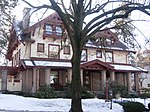
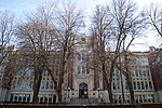
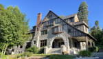
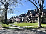
The Marycliff-Cliff Park Historic District is a historic residential area in the Cliff/Cannon neighborhood of Spokane, Washington, located immediately uphill from the city's downtown core, listed on the National Register of Historic Places (NRHP). The district is made up of two distinct but connected areas, the Marycliff section located at the base of a basalt cliff and south of Seventh Avenue, and the Cliff Park section located atop the cliff and north of 14th Avenue. Encroachment from the nearby city center has changed the nature of the Marycliff section over the decades. Of the palatial homes built in the late 1800s in the area, all have either been converted to commercial or public use or razed to make way for new development, though there are still a number of properties that are intact and reflect the historic nature of the area. The Cliff Park section retains its original residential character and historic nature, with only 11 properties listed as intrusive among the 118 properties in the area.Built between 1889 and 1941, the historic district is home to numerous architectural styles. Examples of Jacobethan Revival, Georgian Revival, Bungalow, International Style and Spanish Colonial Revival structures can be found in the district. There are a handful of modern intrusions in the area, including the Kenneth and Edna Brooks house built in 1956, which was listed individually on the NRHP on its own merit in 2004. The property is interesting as it is considered an intrusion to the historic district, but historic enough on its own nonetheless to have been listed on the NRHP.The historic district's location along and atop a cliff overlooking the city center played a prominent role in its development. Wealthy residents in the then nascent city of Spokane built mansions in the Browne's Addition neighborhood, along flat land just west of downtown. When space began to run out there, construction of homes for wealthy and prominent residents shifted to the area south of the city center in what is now the Marycliff area of the district, and later up the cliff to the Cliff Park section. Numerous high-profile architects designed homes in the district, including Kirtland Cutter, who built homes along Cliff Drive to resemble scaled down versions of English country manors. Other architects including Waterhouse & Price, Karl Malmgren, Albert Held and G.A. Pehrson, among others, designed homes in the district.

Ninth Avenue Historic District

The Ninth Avenue Historic District is a National Register of Historic Places (NRHP) listed historic district located along and around Ninth Avenue in the Cliff/Cannon neighborhood of Spokane, Washington. It stretches from Monroe Street on the east to Chestnut Street on the west, running the length of Ninth Avenue and extending to include portions of Eighth, 10th and 11th Avenues, mostly in the western half of the district. A residential area, the district was built to house many of early-Spokane's elite residents in grand Queen Anne, Colonial Revival, Classical Revival, American Foursquare and Tudor Revival homes, along with numerous Bungalow homes for middle-class residents. The area was developed largely between 1892 and 1940, with limited modern incursions in the form of apartments having been built in the decades since. It retains its residential character to this day, though many of the large single-family homes have been converted into multi-unit dwellings. Located roughly one mile from the heart of Downtown Spokane, the Ninth Avenue Historic District is an example of an early residential development in Spokane, free of commercial incursions. Notable architects including Kirtland Cutter, Willis Ritchie, Julius Zittel, Loren L. Rand, John K. Dow and Albert Held designed homes in the district. In the present day, the area is part of the Cliff/Cannon neighborhood of Spokane, stretching from the historic Cannon's Addition in the west over to Monroe Street, a major arterial extending from the north side of Spokane through downtown and up onto the South Hill, in the east. It makes up part of what is now known as the "lower South Hill" for its location near the bottom of a hill which rises abruptly from the downtown area to the north. The terrain surrounding the Ninth Avenue Historic District falls off dramatically on the west to a valley containing Latah Creek, which marks a natural western boundary, and drops to the north to the valley of the Spokane River and Downtown Spokane in the north, while terrain rises to the west and south as one continues up into the South Hill residential area of Spokane.