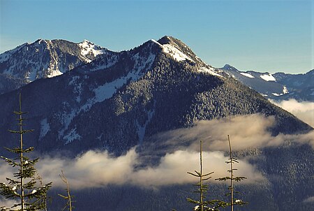
Mailbox Peak

Mailbox Peak is a 4,841-foot-elevation (1,476 m) mountain located in King County of Washington state. It is set west of the crest of the Cascade Range, on land managed by Mount Baker-Snoqualmie National Forest. Mailbox Peak is situated seven miles east of North Bend, and one mile northeast above the Washington State Fire Training Academy. Precipitation runoff from the south side of the mountain drains into the South Fork Snoqualmie River, whereas the north side drains to the Middle Fork of the Snoqualmie. The summit lies along a ridge containing Dirtybox Peak, its topographical parent, and Dirty Harry's Peak. Topographic relief is significant as the northwest aspect rises nearly 4,100 feet (1,200 meters) above the Middle Fork in 1.25 mile. The popular Mailbox Peak Trail gains 4,100 feet of elevation over 5.5 miles. Prior to 2014 when the new trail was completed, climbing Mailbox Peak involved 4,000 feet gain in only 2.6 miles along an unmaintained route that was used for conditioning for major climbs, and recruits from the Fire Training Academy would celebrate graduation by carrying a fire hydrant to the summit. The peak is named for a mailbox at the top which functions as the summit register, but this toponym has not been officially adopted by the U.S. Board on Geographic Names.
Excerpt from the Wikipedia article Mailbox Peak (License: CC BY-SA 3.0, Authors, Images).Mailbox Peak
Mailbox Peak Trail,
Geographical coordinates (GPS) Address Nearby Places Show on map
Geographical coordinates (GPS)
| Latitude | Longitude |
|---|---|
| N 47.462465 ° | E -121.63942 ° |
Address
Mailbox Peak Trail
Mailbox Peak Trail
Washington, United States
Open on Google Maps


